Dewberry Selected to Acquire, Process Lidar Data for Southern Idaho
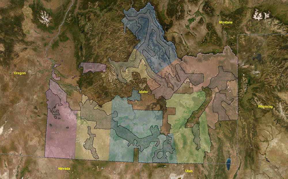
Firm to produce lidar-derived elevation products for approximately 42,000 square miles.
Dewberry has been selected by the U.S. Geological Survey (USGS) to acquire, process, and develop QL1 and QL2 lidar-derived elevation products for approximately 42,304 square miles in southern Idaho, as well as some areas of the neighboring states of Oregon, Montana, Wyoming, Nevada, and Utah. The initial lidar survey began in the fall of 2019 and will continue through the spring of 2020, with all lidar acquisition expected to be completed by October 31, 2020.
The project will support the Federal Emergency Management Agency (FEMA) Risk Mapping, Assessment, and Planning (MAP) program; the National Resources Conservation Service (NRCS) high-resolution elevation enterprise program; and the 3D Elevation Program (3DEP) mission of the USGS to complete acquisition of nationwide lidar. Goals also include acquisition of high-quality lidar to support management of the Boise National Forest as well as the Bureau of Land Management’s (BLM) management of Abandoned Mine Lands and delineation of the Jarbidge Wilderness Area.
“We are excited to work on this project for USGS and its partners to support the 3DEP mission,” says Amar Nayegandhi, CP, CMS, GISP, vice president of geospatial and technology services for Dewberry. “As we move west to complete the USGS goal of a nationwide, high-resolution 3D elevation dataset, we are partnering with various small businesses in private industry to acquire high-resolution lidar data using state-of-the-art sensor technology. Dewberry’s sensor-agnostic approach to data acquisition enables us to select the most appropriate sensors suite for each project.”
“Mapping from the Rocky Mountains of Idaho to the Jarbidge Wilderness Area and Owyhee Mountains in the west with complex weather patterns presents several challenges” says Srinu Ratnala, project manager, geospatial and technology services for Dewberry. “We have designed this project to support the requirements of QL1 and QL2 data acquisition using six acquisition partners with ten ultra-high performance lidar sensors. The lidar data and derivative products will comply with the ‘National Geospatial Program Lidar Base Specification Version 1.3.’”
Author

Parul Dubey
Video: New Roundabout Under Construction at McIver and Old Florence Roads in Darlington County

K2b Cantonal Highway
June Issue 2026
.jpg?width=225)