
Quantum Spatial Speeds Utility Pole Clearance and Load Analysis with inSITE Pole Manager
Quantum Spatial, Inc., an NV5 company and North America’s largest geospatial data firm, today announced a pole clearance and loading analytics solution that will enable electric and telecommunications utilities to complete pole inspections faster, safer and with greater accuracy than traditional boots-on-the-ground methods. Quantum Spatial’s inSITE Pole Manager delivers full-system functionality, providing utilities with real-time snapshots of outstanding risk, and allowing them to seamlessly create work orders, forecast resources, dispatch assignments to remove field workers and track work progress from a single integrated platform.
“With more than 170 million poles spanning the United States, electric and telecommunications utilities face increased pressure from regulatory compliance and an increase in attachment requests related to 5G rollout. Under this pressure, it’s hard for utilities to keep pace, particularly at a time when many field workers are nearing retirement,” said Eric Merten, vice president and general manager at Quantum Spatial. “inSITE Pole Manager addresses these challenges, delivering more accurate and repeatable information, and enabling utilities to proactively address risk by planning repairs, upgrades and vegetation management when and where they are needed most.”
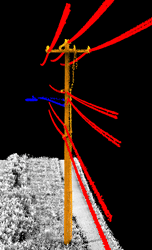
inSITE Pole Manager leverages high-resolution spherical imagery and lidar data, which is acquired using 3D laser scanning technology with a survey-grade accuracy of 2 cm. The process begins with a clearance analysis based on utility standards and the governing regulations, then pole loading based on the utility specifications. This data enables the platform to perform full load analysis on 10,000 poles in two months, which is up to six times faster than what a utility can achieve with boots-on-the-ground. In addition, the processes take human error out of the measurement process. The lidar point cloud provides a “digital twin” with measurements that are systematic and repeatable.
Collected data is analyzed within Quantum Spatial’s inSITE software and delivered on a viewable and searchable map, which allows utilities to quickly identify and prioritize problem areas. inSITE Pole Manager also includes the ability to generate a 3D model of each pole. This feature eliminates the tedious task of manually creating pole models, allowing users to create models of 50 poles in three seconds – 60,000 times faster than traditional manual processes.
Key inSITE Pole Manager features include:
- Cloud-based geospatial platform – Displays all integrated assets and collected data as features in a spatially correct map view.
- Industry standard maps – Offers optimal compatibility with third-party map services, integrated GIS and asset management systems.
- Directly links map to 3D viewer – Supports a large range of geographic and projected coordinate systems for 3D data.
- Integration with standard web map services – Displays data layers sourced from external GIS and asset management systems in real-time to view collected data and data layers.
- Adapters – Quantum Spatial licenses or develops adapters to integrate data from non-standard web map services and geospatial APIs.
- Out-of-the-box functionality – Ability to add and display layers from public, third-party services, such as weather service, wildfire boundaries, and environmental data.
To learn more about inSITE Pole Manager, email [email protected] or come see a demonstration at Quantum Spatial’s booth 1652 during Distributech, January 28-30 in San Antonio.
About Quantum Spatial, Inc.
Quantum Spatial, Inc., an NV5 company, provides geospatial intelligence to government and corporate organizations to mitigate risk, plan for growth, better manage resources and achieve advanced scientific understanding. A pioneer in advanced mapping technology, Quantum Spatial’s end-to-end solutions deliver data and services of the highest quality and accuracy, leveraging the widest array of technologies in all types of landscapes. Clients use the company’s acquisition, processing, analytics and visualization solutions in a range of technical and scientific disciplines – from geology and biology, to hydrology, forestry and civil engineering. Utilities, oil and gas producers, engineering and construction firms, as well as the military and major government agencies, are Quantum Spatial customers. Quantum Spatial has multiple offices around the country. For more information visit quantumspatial.com, join us on LinkedIn or follow us on Twitter @QuantumSpatial.
About NV5
NV5 Global, Inc. is a provider of professional and technical engineering and consulting solutions ranked #34 in the Engineering News-Record Top 500 Design Firms list. NV5 serves public and private sector clients in the infrastructure, energy, construction, real estate, and environmental markets. NV5 primarily focuses on five business verticals: construction quality assurance, infrastructure engineering and support services, energy, program management, and environmental solutions, and delivers geospatial services through its subsidiary Quantum Spatial, Inc., the largest full-service geospatial solutions provider in North America. The Company operates out of more than 100 locations worldwide. For additional information, please visit the Company’s website at www.NV5.com
