New Integration for Autodesk Civil 3D
Our partnership with Esri continues to develop, enabling more streamlined flow of data between design tools and GIS. Now, the integration of BIM and GIS has come to Civil 3D!
Autodesk® Civil 3D® continues to deliver improvements to design, performance and collaboration efficiencies, enhancing BIM design workflows for larger, more complex infrastructure projects. However, with this latest release – Civil 3D 2020.1 – we are extremely excited to introduce the Autodesk Connector for ArcGIS in Civil 3D, allowing you to directly to connect to the GIS data you need in Esri’s ArcGIS Online.
“I’m really looking forward to the Connector for ArcGIS integrations with Civil 3D. Currently, a significant portion of our project setup is used to gather and georeference a variety of available data. This will greatly streamline the effort.”
– Rafael Rodriguez, Cobb Fendley
With the Connector for ArcGIS you can bring ArcGIS data layers that contains points, lines, polygons, feature lines, gravity pipes, parcels, or structures into your Civil 3D drawings. When you bring in each layer, you can specify what type of Civil 3D object to create. This helps you more efficiently generate the existing conditions for your specific area of interest.
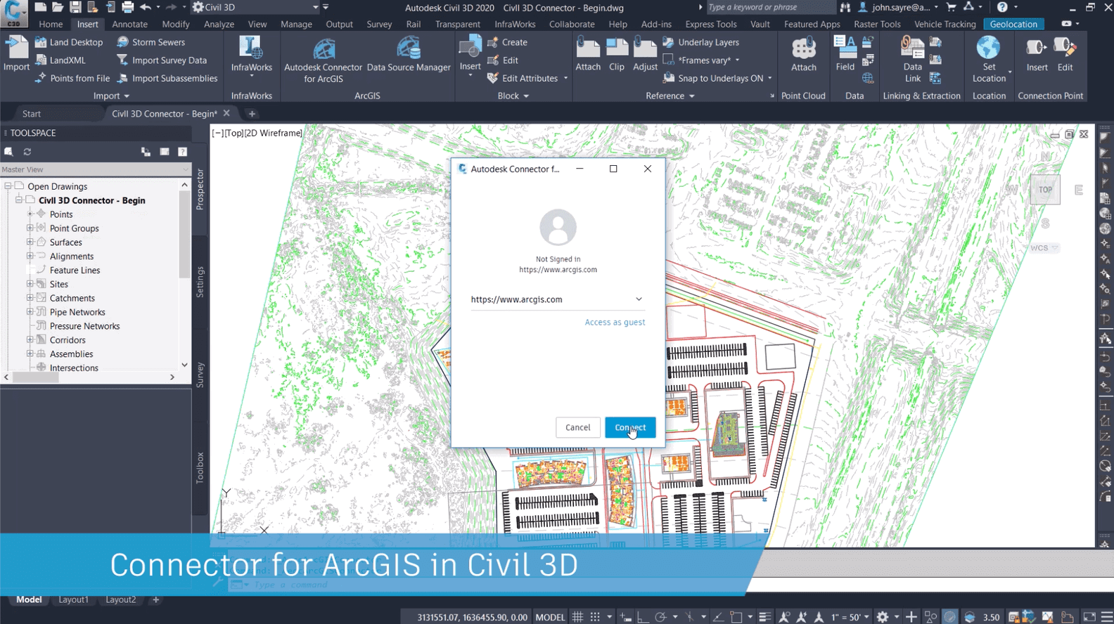
Assuming you have the proper privileges in ArcGIS, you can now bring GIS data into from ArcGIS directly into a Civil 3D drawing and make changes to that data in Civil 3D. With the Save Back option in the Data Source Manager, you able to update your changes back into ArcGIS. Because the Connector for ArcGIS maintains a live link to ArcGIS Online, this helps ensure that consistency is maintained between what is being designed and what is in the GIS.
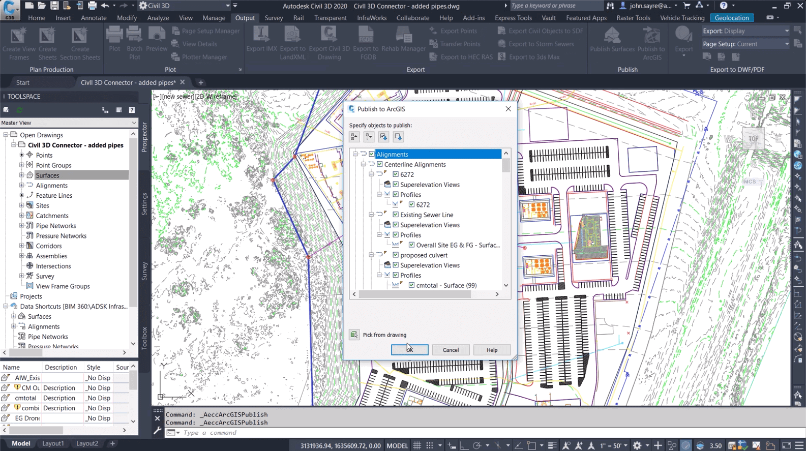
Now, not only can you Save Back to ArcGIS, you can also Publish Civil 3D objects to ArcGIS, including: alignments, feature lines, parcels, pipe networks, and points. Why would you want to do this? With the ability to Publish to ArcGIS, as you go through design process and reviews, you can create new features that are needed for your project and update those back into ArcGIS directly. This helps ensure that not only existing conditions data is up to date, but all stages of the project data is up to date and can be accessed by all stakeholders.
You can also connect to ArcGIS in order to bring in data to create gravity pipes and structures. To do so, you will need to first set schema mapping settings in order to map the specified ArcGIS attributes to Civil 3D properties. Bringing in data to create gravity pipes and structures in this manner helps eliminate errors and saves time.
“We often need to overlay floodplains, wetlands, parcel lines, and easement lines. A lot of this information only comes from our environmental department and might have taken a day or two to obtain. Now, it is easily accessible to us, at a moment’s notice, using the Connector.”
- John Mayo, licensed professional engineer and Autodesk Civil 3d Expert Elite member
Last, but not the least, the Export to FGDB command enables you to export specific Civil 3D objects – alignments, feature lines, parcels, pipe networks, and points – to a file geodatabase that can be used in ArcGIS or other application.
But wait, there’s more…
While we’ve focused on BIM & GIS integration capabilities, here are a couple of other new features in Civil 3D 2020.1.
To better manage standards, you can now use enhanced reference template features to manage styles and settings.
For rail projects, you can now create dynamic 3D polylines or feature lines from a rail alignment that represent the left, center, and right rail lines.
Learn more about Civil 3D by visiting the Civil 3D product center.
You can also discover more about BIM & GIS by visiting our website or go to the Autodesk Infrastructure YouTube channel and get your hands on videos about integrating GIS with design. You also find other technical videos on Civil 3D and other Autodesk BIM software for Infrastructure. You can also discover how you can extend your workflow with the other tools available in the Autodesk AEC Collection.
If you’re not a user yet, you may want to give Civil 3D a try or go ahead and subscribe today.
Autodesk® Civil 3D® continues to deliver improvements to design, performance and collaboration efficiencies, enhancing BIM design workflows for larger, more complex infrastructure projects. However, with this latest release – Civil 3D 2020.1 – we are extremely excited to introduce the Autodesk Connector for ArcGIS in Civil 3D, allowing you to directly to connect to the GIS data you need in Esri’s ArcGIS Online.
“I’m really looking forward to the Connector for ArcGIS integrations with Civil 3D. Currently, a significant portion of our project setup is used to gather and georeference a variety of available data. This will greatly streamline the effort.”
– Rafael Rodriguez, Cobb Fendley
With the Connector for ArcGIS you can bring ArcGIS data layers that contains points, lines, polygons, feature lines, gravity pipes, parcels, or structures into your Civil 3D drawings. When you bring in each layer, you can specify what type of Civil 3D object to create. This helps you more efficiently generate the existing conditions for your specific area of interest.
Assuming you have the proper privileges in ArcGIS, you can now bring GIS data into from ArcGIS directly into a Civil 3D drawing and make changes to that data in Civil 3D. With the Save Back option in the Data Source Manager, you able to update your changes back into ArcGIS. Because the Connector for ArcGIS maintains a live link to ArcGIS Online, this helps ensure that consistency is maintained between what is being designed and what is in the GIS.
Now, not only can you Save Back to ArcGIS, you can also Publish Civil 3D objects to ArcGIS, including: alignments, feature lines, parcels, pipe networks, and points. Why would you want to do this? With the ability to Publish to ArcGIS, as you go through design process and reviews, you can create new features that are needed for your project and update those back into ArcGIS directly. This helps ensure that not only existing conditions data is up to date, but all stages of the project data is up to date and can be accessed by all stakeholders.
You can also connect to ArcGIS in order to bring in data to create gravity pipes and structures. To do so, you will need to first set schema mapping settings in order to map the specified ArcGIS attributes to Civil 3D properties. Bringing in data to create gravity pipes and structures in this manner helps eliminate errors and saves time.
“We often need to overlay floodplains, wetlands, parcel lines, and easement lines. A lot of this information only comes from our environmental department and might have taken a day or two to obtain. Now, it is easily accessible to us, at a moment’s notice, using the Connector.”
- John Mayo, licensed professional engineer and Autodesk Civil 3d Expert Elite member
Last, but not the least, the Export to FGDB command enables you to export specific Civil 3D objects – alignments, feature lines, parcels, pipe networks, and points – to a file geodatabase that can be used in ArcGIS or other application.
But wait, there’s more…
While we’ve focused on BIM & GIS integration capabilities, here are a couple of other new features in Civil 3D 2020.1.
To better manage standards, you can now use enhanced reference template features to manage styles and settings.
For rail projects, you can now create dynamic 3D polylines or feature lines from a rail alignment that represent the left, center, and right rail lines.
Learn more about Civil 3D by visiting the Civil 3D product center.
You can also discover more about BIM & GIS by visiting our website or go to the Autodesk Infrastructure YouTube channel and get your hands on videos about integrating GIS with design. You also find other technical videos on Civil 3D and other Autodesk BIM software for Infrastructure. You can also discover how you can extend your workflow with the other tools available in the Autodesk AEC Collection.
If you’re not a user yet, you may want to give Civil 3D a try or go ahead and subscribe today.
Author

Parul Dubey
Video: New Roundabout Under Construction at McIver and Old Florence Roads in Darlington County

K2b Cantonal Highway
June Issue 2026
.jpg?width=225)