
When megacities (with populations of more than 8 million) top these types of rankings, it’s easy to lose sight of the areas of real opportunity. In fact, much of the innovation and explosive growth in the Smart City arena is happening in small and midsize cities.
This makes sense. Although megacities have the staff and budgets to really embrace some of the cutting-edge technology, midsize and smaller cities can be agile with their implementations, starting projects on small scales, iterating to find what works, and then scaling up.
In fact, it’s GIS departments of smaller cities that are seeking to reinvent their workflows. Instead of creating static maps that require high overhead and heavy maintenance, they’re turning to do-it-yourself geospatial apps that allow non-geospatial experts to tap into the power of location intelligence, mitigating the technology budget challenges in smaller cities.
For example, smaller and midsize cities need cost-effective ways to analyze their services as citizens call in reporting in real time. This type of proactive analysis helps cities improve the quality of life for citizens.
Baton Rouge
With a population of 227,000 and serving a metropolitan area of more than 830,000, Baton Rouge, La., is a prime example of a city that’s leveraging geospatial innovations for visualizing and understanding its most-pressing challenges. Driven by the creation of its Smart City Committee in 2016, the City of Baton Rouge is proactively identifying opportunities to enhance public policy and decision-making, data management and collaboration, and civic engagement and education.
To solve these wide-ranging problems, Baton Rouge needed a solution that would let it combine existing enterprise GIS data with other departmental data sources such as financial information, 311 citizen requests for service and traffic data. This solution also had to be easy to use by various department leaders without overtaxing the city’s GIS staff.
Baton Rouge chose M.App Enterprise from Hexagon’s Geospatial division to combine the power of GIS with its specific business data. The solution enables the city to deploy compelling location-based business intelligence apps, called Hexagon Smart M.Apps, to be run by city employees in web browsers.
The result isn’t just a static map, but a live dashboard that encourages the exploration of data across multiple charts, simultaneously. This dynamic interaction provides several perspectives in one tool and avoids the need for additional applications. By allowing users to dynamically adjust the charts, it’s simple to explore location-based data based on combinations of conditions as well as temporal and spatial parameters to identify patterns and trends.
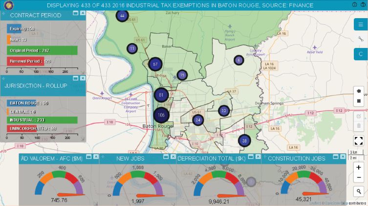
The finance department can gain insights to address how much a council district is losing in terms of revenue due to industrial tax exemptions. It’s possible to focus on specific industrial businesses across the metropolitan council districts by combining financial data with GIS data. Gauges are used to visually display the breakdown of data by loss of actual tax revenue by city function.
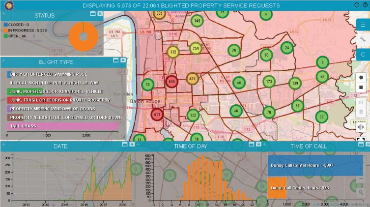
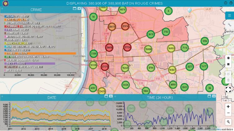
When addressing blighted properties, the city can explore the relationship with crime to help prioritize resources. The analytic offers the average time to resolve the blighted property reporting issues by each council district to provide performance metrics on city services.
Traffic analyses help determine which intersections have the largest number of vehicle and pedestrian accidents and combine them with traffic volumes, allowing traffic engineers to prioritize where safety improvements need to be made. The solution also allows for analyzing crashes based on time, date, location, manner of collision and road condition.
Overall, these types of location intelligence solutions can address an even wider range of city operations, including water systems, streetlight management and crowd-sourced citizen data.
For example, with growing populations in cities of all sizes, it’s inevitable that water consumption also will grow. New online platforms for geospatial infrastructure management of water and sewerage offer accessible content that’s continually updated in real time with compelling location-intelligence analytics to drive decisions, communicate status and collaborate on actions. Streetlight management solutions help develop light inspection workflows, offer an interactive dashboard for at-a-glance views of light power usage over an entire city, and can provide mobile alerts to city workers when there’s an outage.
With many of the efforts being connected, these types of Smart City systems need to be effectively visualized, monitored and analyzed for optimal collaboration and communications. For example, data about broken streetlights can point to more crime incidents, and underground infrastructure status can impact road-paving schedules.
Power to the People
Citizen engagement also helps cities become smarter. Location-based apps quickly capture citizen issues, visualize them and ultimately drive rapid decision-making. This allows city leaders to show performance improvements, which is what Baton Rouge plans to do with its 311 Smart M.App.
The Baton Rouge implementation is a prime example of how bigger isn’t always better when it comes to embracing Smart City solutions. Smaller and midsize cities have the agility and ability to iterate solutions for delivering relevant geospatial data, workflows and analytics, on any device, into the hands of local government and residents interested in making the city a better place to live.

Dave Holmes
Dave Holmes is a business consultant at Hexagon’s Geospatial division; email: [email protected].
Video: New Roundabout Under Construction at McIver and Old Florence Roads in Darlington County

Bridge Replacement at Amsterdam Centraal Station

June Issue 2026
.jpg?width=225)