
The Mobile Mapping System Road-Scanner for the First Tram Line in Bologna (IT)
Bologna, Italy – SITECO Infomatica SRL, in collaboration with the Engineering Department of the University of Messina, carried out the high-precision survey for the technical and economic feasibility planning of the first tramway (red line) in Bologna (IT).
The project was realized in the context of the assignment to Siteco by the Temporary Association of Companies including Systra SA, Systra-Sotecni SpA, Architecna Engineering Srl, STUDIO MATTIOLI Srl, AEGIS Srl and CANTERELLI & PARTNERS LEONARDO Srl., and the University of Messina.
The realization of the project, born from a European tender issued last July, required technical verification of feasibility which the team successfully performed with the implementation of the Mobile Mapping System Road-Scanner4.
The planned railway route will develop for about 15 kilometers with two terminus stations: the first northeast of the city near FICO Eataly World, the well-known Italian agricultural-food park of the national farming tradition, and the second one, northwest, in the Borgo Panigale area, beyond the Ducati Motor Holding SpA headquarters. The tram route also includes stops in the historical center.
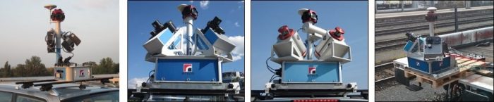
Approximately 30 km of roads have been surveyed with the Road-Scanner4. The system was equipped with a spherical Ladybug5 camera, 2 Faro S70 laser scanners, a LANDINS IXSEA inertial system, and a DMI odometer.
The collected data were then processed with the Road-SIT Survey plugin in the AutoCAD environment. This allowed displaying the point clouds on the imagery, carrying out the feature extraction and adding the required measurements quickly and efficiently. All objects can also be displayed in 3D format (sidewalks, walls, poles, etc.), thus enabling a realistic and comprehensive overview. The survey covered sidewalks, road sections for disabled people, buildings and fences, public lighting poles, electric poles, and traffic lights.
“I’m satisfied from a technical point of view, obviously”, says Ing. Augusto Burchi, Siteco’s Technical & Sales Director, “but I’m also happy that Siteco had the opportunity to contribute to this project which demonstrates Bologna’s ability to renew itself exploiting new technologies, while retaining its profile as a great historical city.”
About Siteco Informatica srl – A unit of the Gavio Group, one of Italy’s top industrial groups, Siteco was established in 1995 as a civil engineering infrastructure, software and technical consulting firm. In 2005 they developed the first scalable, high performance fully integrated mobile mapping system and have since then been delivering the most flexible roadway management mobile mappers in terms of price, performance and software usability. Siteco’s Road Scanner hardware and software products are fully compatible with Faro, Z+F, Leica, Riegl, Teledyne Optech, Topcon, Teledyne and other mobile mapping systems and sensors.
About the Engineering Department of the University of Messina – The current Department of Engineering was founded in 2015, merging the Department of Civil Engineering, Computer Science, Construction, Environmental and Applied Mathematics with the Department of Electronic Engineering, Chemistry and Industrial Engineering.
The new department has a special focus on the advanced technologies, provides wide and articulated educational competences, an increasingly rich research activity and constant relations with external operators.
