
Datumate’s DatuSurvey™ 5.5 supporting Large Scale Construction Projects
Wide area construction projects require large amount of data to be processes effectively (scale and time) on a desktop or in the Cloud. With the fast adoption of drones and photogrammetry solutions by land surveyors and construction project managers who want to process their project “as-built” data on their desktop or organizational network, Datumate is happy to announce its enhanced new offering for individual or organizations’ Survey and Construction Professionals.
With its new DatuSurvey™ 5.5, organizations deploy Datumate’s solutions on single or multiple computers and take advantage of the accelerated and user-friendly processing of the project field data.
Large construction sites are going through frequent changes, construction professionals require solutions that will provide actionable data on a daily basis:
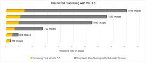
- Ability to process large amount of drone imaging data (hundreds and thousands of images)
- Locally (on their desktop in the field or in the office) Quickly (within hours)
- Achieve survey grade accuracy and geo-reference the model quickly and easily
- Plan and execute consecutive drone missions on un-mapped and frequently changing areas
With the new DatuSurvey™ 5.5 which traditionally offers a unique 2D vectorized measurements and 3D point clouds models, users can now process hundreds and thousands of images locally in an accelerated mode while maintaining survey grade accuracy and professional engineering results.
Datumate’s core competency is rooted in a team of construction and technology experts that understand the construction processes end to end and the need for survey grade results, efficiency and cost saving. For that, we’ve improved dramatically the geo-referencing workflow when using Ground Control Points (GCPs). Users can now quickly and easily mark GCPs using zoomed-in image projections on a large number of images. This process will enable users to achieve survey grade accuracy quickly in the most efficient way.
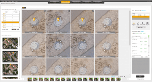
Image acquisition on large and unmapped construction projects can be a challenge, as these areas are frequently changing and users want to execute drone missions on specific areas without spending a lot of time on planning. For that reason, we’ve added the ability to import coordinates (in KMZ\KML format) to DatuFly™ Professional in addition to on-site\on-map mission planning. This will enable an efficient and accurate drone mission execution on specific and designated areas without depending on satellite and map source views.
Step #1: Log in to DatuFly™ Professional portal with your DatuFly™ Professional credentials to upload job coordinate file (in KMZ\KML format)
Step #2: In DatuFly™ Professional app, create a new mission and import the job you’ve uploaded to the portal
A list of additional valuable features and capabilities were added in DatuSurvey™ 5.5. To learn more about all features and capabilities of DatuSurvey™ 5.5, you are welcome to visit our resource page and read the release notes.
