
Announcing Release of UgCS v.2.12 and UgCS for DJI v.2.8 Update
Riga – SPH Engineering announces the release of the UgCS and its mobile companion’s UgCS for DJI update perfecting user experience and features for professional UAV survey mission planning. Along with the update, the UgCS Mapper (beta) is made available – a geo-referenced image processing desktop software, to create preliminary orthophoto map in-field, requiring no internet connection.
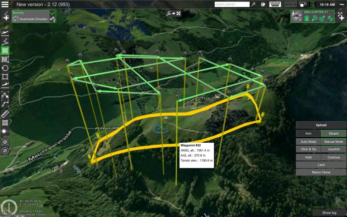
The double grid option is added for Area scan and Photogrammetry tool, to enable more precise aerial data acquiring. When a new Photogrammetry area is being added to the survey mission, by default the action Camera by time (with auto flag) is added.
For more comfortable mission planning features like the option to move and rotate route, manage common actions for selected segments and displaying of calculated path leg length on cursor-hover, polygon side length and calculated area size is displayed.
“Data import, flight planning and control are features that characterise UgCS. Adding the desktop geo-referenced image processing software UgCS Mapper to our portfolio brings UgCS one step closer to a complete ground control and mapping platform for UAV professionals. For our customers UgCS Mapper will provide significant insight to acquired data quality on site – this will save time and ensure better result – a PRO solution for PRO’s!”, said Janis Kuze, Sales Director at SPH Engineering.
While in beta UgCS Mapper is available for all users, after official release it will be a part of UgCS PRO and UgCS ENTERPRISE package.
For Ardupilot added the option to connect over UDP, added command and action SET_SERVO and REPEAT_SERVO and to set constant heading (disable yaw to next waypoint).
Some of the new UgCS for DJI features: for drones with multiple videos feeds option to select video source added, zoom control widget improved and a notification is displayed when a waypoint is reached and left.
Download latest UgCS version: www.ugcs.com/download
Download latest UgCS for DJI version: www.ugcs.com/download_app_for_dji
About UgCS
UgCS is a complete platform developed by SPH Engineering to plan and fly drone survey missions. Automated drone mission planning, built-in photogrammetry and geotagging tools, map customisation and battery exchange option for long routes make UgCS an effective solution for professional applications. UgCS is unified mission planner for all popular UAV platforms to control and monitor one or multiple drones on a single mission, in multi operator mode or multi-platform environment. SPH Engineering offers unmanned systems integration services: building, acquiring and consulting on the selection of airframes, autopilots, payloads for a particular application and performing proof of concept projects and software development. More: www.ugcs.com
