
InfraWorks and AutoCAD Civil 3D 2018: They’re Here!

April 13, 2018. The latest Autodesk InfraWorks and Autodesk AutoCAD Civil 3D 2018 are officially released today. Throughout the year many of you have met with our product managers and development teams; and, many, many more of you have shared your Ideas for product feature enhancements. Your involvement in the development of our solutions is invaluable, helping us bring you the tools you need to conceive, design and construct road, highway, bridge, land, and other infrastructure projects in ways that are more economical, practical, resilient, and attractive. While you’ll hear more about the latest feature capabilities in the coming weeks, this post gives you a peek at the highlights of what’s new in InfraWorks and Civil 3D 2018.
Let’s have a look at what these new offerings bring.
Autodesk InfraWorks
We continue to invest to extend the value of InfraWorks as a BIM for Infrastructure modeling platform for civil engineers and architects. In the last year, we’ve made significant improvements in its engineering design capabilities. At the same time, we to make InfraWorks an even better tool for preliminary design of your projects. For this latest release, we’ve focused on these areas of feature enhancements:
- Experience – Enhancements that enable views of your design with greater engineering context.
- Modeling – We’ve made even more improvements to the modeling of roads and bridges.
Here are just a few of the new capabilities:
Manage Bridge Components. Manage inventor-based bridge components directly in the Style Palette where you can easily add parametric content like decks, piers, and girders. You can even use all the commands you’re familiar with to manage these components.
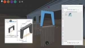
Figure 1. Bridge modeling – custom piers. Image courtesy of Autodesk.
Material Quantities. Quantify more aspects of materials for a selected road like road components, bridge materials, and drainage components. Export the quantities to a CSV file for further review, reporting, or cost estimating. You can even customize the quantities panel to show only the categories you would like to see or export.
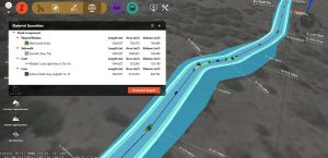
Figure 2. Material quantities. Image courtesy of Autodesk.
Simplified Trees. Substitute realistic trees for “simplified trees” to improve the performance (faster regen, panning and zooming) when large stands of trees, such as forests, are part of the model.
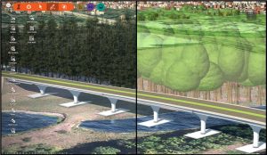
Figure 3. Simplified trees. Image courtesy of Autodesk.
Usability Enhancements. A new gizmo makes it easier to edit roadside grading. And, making modifications to grading zones just got faster and more responsive. We’ve also made improvements to the performance of annotations on certain assets, including selected roads, parcels, easements and rights-of-way and some measurement tools. Annotation styles have improved readability, they are more responsive as you zoom in and out, and they respond more effectively as you change your view perspective.
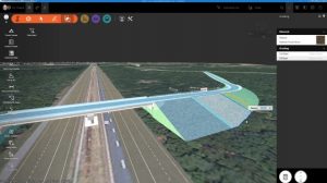
Figure 4. Improved grading zone editing. Image courtesy of Autodesk.
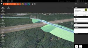
Figure 5. Improved annotation performance. Image courtesy of Autodesk.
Autocase for Sites. Directly from InfraWorks, users will now have access to the Autocase for Sites solution, free for a period of one year. Autocase for Sites provides data and analytics to automate the business case for stormwater projects in North America. Using basic project data and carefully curated economic data, Autocase for Sites automates “triple bottom line (TBL) cost benefit analysis (CBA)”, including lifecycle cost analysis, to help prioritize design elements that will optimize the financial, social and environmental bottom line of a project. Autocase for Sites can help you evaluate over 25 stormwater design features to quantify and monetize the reduction in flooding, avoided gray infrastructure, water and air quality improvement, recreation improvement, reduced carbon emissions, and the property value benefits of green infrastructure.
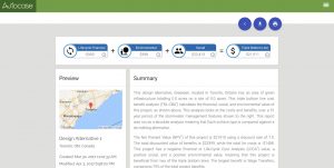
Figure 6. Autocase for Sites. Image courtesy of Autodesk.
Other features and enhancements include:
- Road annotations
- Converting design roads to component roads
- Feedback when standards are broken
Oh, and we’ve also changed its name (slightly). With this latest release, InfraWorks 360 is now officially, and simply, InfraWorks.
AutoCAD Civil 3D
Every AutoCAD Civil 3D user should be using InfraWorks to more effectively perform preliminary engineering design on their projects. Then, projects can be completed with AutoCAD Civil 3D, which continues to be the Autodesk solution for detailed design and the delivery of construction documentation of infrastructure projects. The release of AutoCAD Civil 3D 2018 focuses on three themes: design efficiency, production efficiency, and collaboration.
Here’s a look at just a few of the new features in AutoCAD Civil 3D 2018.
Launch InfraWorks. The new InfraWorks ribbon in AutoCAD Civil 3D 2018 now gives you access to InfraWorks-related commands and enables you to launch InfraWorks directly from that ribbon.
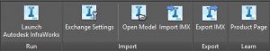
Figure 7. InfraWorks ribbon in AutoCAD Civil 3D 2018. Image courtesy of Autodesk.
Resolve Corridor Bowties. In AutoCAD Civil 3D 2018, when you have corridor tangents intersect at a corner, or the corridor is created at a fixed width, the inner and outer corners of corridors are now cleaned up automatically. You can even clean up corners from corridors you bring forward from prior versions of AutoCAD Civil 3D by simply making an edit to the corridor and rebuilding it. And, you can use the Clear Corridor Bowties command, when the corridor is created at a non-fixed width (such as when daylighting to a surface).
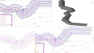
Figure 8. Resolve corridor bowties. Image courtesy of Autodesk.
Plan Production Tools. New drawing templates have been added in AutoCAD Civil to accommodate the ability to create plan/plan and
profile/profile sheets in AutoCAD Civil 3D 2018The plan production tools in AutoCAD Civil 3D 2018 allow you to more quickly create construction documents by allowing you to create plan(s)-only, profile(s)-only, and section sheets.
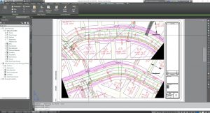
Figure 9. Plan production tools. Image courtesy of Autodesk.
Connected Alignments. The new connected alignment capabilities in AutoCAD Civil 3D 2018 allows you to create a new dynamically linked alignment and profile that transitions between two intersecting alignments and their profiles. You can use this feature to create a curb return, an exit ramp, a merging/diverging road, or you can connect
an existing road with a proposed road.
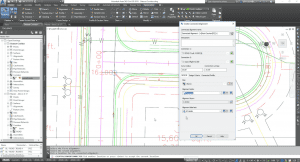
Figure 10. Connected alignments. Image courtesy of Autodesk.
Visit the product centers and discover more about the latest capabilities of AutoCAD Civil 3D 2018 and the latest in InfraWorks.
If you’re on an AutoCAD Civil 3D 2017 subscription license or maintenance plan, you’ll get all your updates as they become available, right in the Autodesk Desktop App. Just accept the update, and you’ll be up and running with the new features immediately.
If you’re a subscriber to InfraWorks, you can get the latest release by going to manage.autodesk.com.
Not yet using these products, take the for a test drive with the 30-day trial – Civil 3D trial, InfraWorks trial – or go to the Autodesk eStore to subscribe today – Civil 3D eStore, InfraWorks eStore.
On behalf of all of us on the Autodesk civil infrastructure team (developers, QA, user experience, product management, product marketing, etc.) thanks to everyone who contributed to this release. We urge you to continue engaging with us via the community forums and sending us your Ideas for InfraWorks and AutoCAD Civil 3D.
