On a monthly basis, the airport’s designers generate dozens of complex, time-consuming maps and facility drawings required to meet corporate and regulatory requirements. To manage compliance with operational safety measures and ensure stakeholder collaboration throughout all phases of facility design, construction and maintenance, the department needed to streamline workflows and facilitate production of accurate drawings and information—then update, publish, share and disseminate efficiently. Using Bentley technology, the design team created a self-service facilities-management system that provides quick, easy access to layout and geospatial data, and improves information mobility among its employees, consultants and stakeholders.
Geospatially Coordinated, Intelligent 3D Assets
The airport design team deployed Bentley Map as a GIS platform to map the ever-changing airport facilities’ assets and capture data intelligence to provide the foundation for Sydney’s AIFMS. Using the array of technologically advanced GIS and topology tools powered by Bentley’s mapping software allowed the team to model the facilities as intelligent, real-world 3D representations and assign attributes to uniquely identify and locate every asset.
Each of the 15,000 doors, tenancies and assets within terminals, car parks and ancillary buildings were identified by a unique number. Working in a collaborative, federated environment and using a map-based interface with project, document and workflow-management tools helped define a consistent approach to classifying and defining the information for all objects. This ensured the AIFMS not only met the different departments’ requirements, but that it was consistent with the naming conventions across the project so information would be easily stored and retrieved.
For example, with more than 8,500 doors in the international terminal alone, it was essential not only for airport staff to know which doors they could enter, but also for security purposes, to be able to identify and locate these doors quickly and efficiently. By mapping all the airport doors with attached criteria on the GIS platform on an ongoing basis, the organization now can use the Web to find any door—by door number or type—with confidence that the information is accurate and up to date.
Project Summary
Organization: Sydney Airport
Solution: Government
Location: New South Wales, Australia
Project Objectives:
- Implement a high-quality Airport Infrastructure Facilities Management System (AIFMS) using innovative engineering and geospatial applications.
- Dynamically share data and enable self-service for project stakeholders to improve operational efficiency and reduce costs.
- Deliver a “single source of truth” to eliminate data duplication and redundancies.
Software products used: Bentley ProjectWise, Bentley Geo Web Publisher, MicroStation, Bentley Descartes, Bentley Map, Bentley Map Mobile, Bentley Pointools, ProjectWise Web Explorer, Bentley Geo Web Map Viewer, Bentley Navigator and ProjectWise WorkSite
Fast Facts
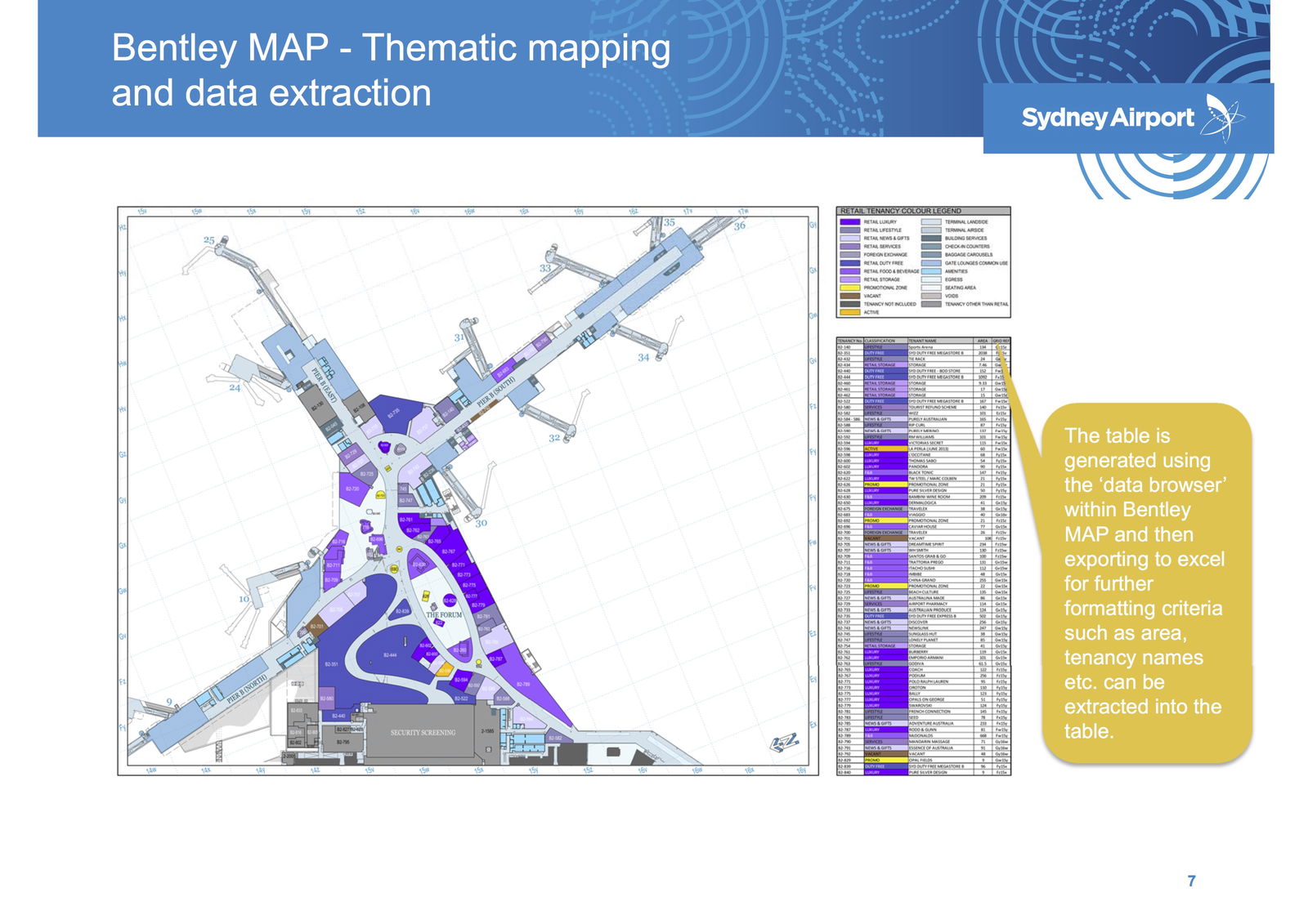
- The airport design team used Bentley Map to map the facilities’ assets and produce on-demand thematic models for use in different airport databases.
- ProjectWise is the primary data storage for facilities design and business-related content, enabling multi-discipline collaboration and providing a single source of truth for the system.
- Geo Web Publisher provides a self-service portal giving stakeholders quick, easy access to design and geospatial data.
- Using Bentley mobile applications enables access to live data from anywhere on the airport’s premises.
ROI
- The AIFMS provides a secure information environment and eliminates data redundancy, saving an estimated 12,395 man hours per year.
- The self-service portal via Geo Web Publisher minimizes data enquiries and reduces turnaround time when requests are necessary, improving operations and maintenance.
- Optimizing information mobility among field staff through mobile applications allows instantaneous data access and faster response times in facility operations.
ProjectWise Delivers “Single Source of Truth”
The entire AIFMS is based on a combination of server applications (ProjectWise, Bentley Geo Web Publisher, SQL Server), desktop applications (MicroStation, Bentley Descartes, Bentley Map, Pointools), Web applications (ProjectWise Web Explorer, Bentley Geo Web Map Viewer), and mobility applications (Bentley Map Mobile, Navigator and ProjectWise WorkSite [formerly Field Supervisor]). The purpose of the system is to manage the engineering design and geospatial content as well as provide a portal for information mobility and access, while facilitating collaboration among project teams, internal department stakeholders, and external agencies involved in managing airport facilities.
AIFMS is designed as a comprehensive program with all databases housed on the ProjectWise server. Capturing, defining, storing and managing facility design standards in ProjectWise enables streamlined processes in a controlled and secure environment ensuring regulatory compliances. The team created standard project templates for numerous processes and used ProjectWise to automate workflows for the work requests, content creation, storage, registrations and approvals.
“ProjectWise allows us to create workflows, manage all our databases, as well as point-cloud data, all our CAD standards and project templates,” explains Kim Cohen, geospatial manager for Sydney Airport.
Using ProjectWise provides onsite/offsite access to facility data in multiple formats and allows integration with various user applications. As the primary data storage and application service center for facilities design and related business content, ProjectWise effectively eliminated data silos and redundancies and enabled effective data sharing and collaboration to deliver the AIFMS as a “single source of truth.”
Organization-wide Graphical Portal
Sydney Airport’s digital print room houses more than 7,500 drawings covering seven disciplines. Although the introduction of CAD significantly increased the accuracy and efficiencies in preparing and amending the drawings, the output was still a manual, static drawing or PDF. Bentley Geo Web Publisher provides a live graphical portal to the entire organization, allowing users to access, identify, locate and analyze information, including links to lease plans and as-built data, and it proved to be an efficient collaboration platform among the airport design team and other departments.
Bentley’s GIS Web software provides dynamic access to design office contents and can capture data and updates from the field using Bentley Map Mobile and other mobile applications. It can hyperlink related documents, and because it is a self-service portal, enables stakeholders to fulfill their own requests in digital form.
“Now they have a live portal where they can do their own analysis and data searching,” notes Cohen.
Numerous airport departments are using Bentley Geo Web Publisher in team meetings to facilitate decision making by displaying tenancies and discussing issues using the redline tool to highlight problem areas rather than preparing PDFs prior and disseminating them to attendees. Concerns can be graphically represented and addressed in real time. Directly integrating with ProjectWise, Bentley Geo Web Publisher helped breakdown prior data silos by facilitating data sharing and collaboration, ensuring data accuracy and reliability within the AIFMS.
Information Mobility Delivers Savings
Leveraging Bentley software with mobile applications enabled the airport to streamline workflow and registration processes to ensure compliance with airspace height restrictions. Second worldwide only to Dubai in the number of cranes erected in the Sydney basin, the airport registers more than 100 cranes per month for a total of 1,200 cranes per year. Registrations and approvals are needed for each crane to ensure appropriate markings and lightings, and that the cranes do not cause interference with radar and navigation equipment.
By creating a workflow in ProjectWise and using Bentley Map, documentation is automatically sent to appropriate agencies, and the exact location of each crane is identified and marked. The active crane symbols are dynamically published in the Bentley Geo Web Publisher portal, enabling airspace protection users to quickly find, display and update the cranes’ parameters. Bentley Map also produces an i-model for Bentley Map Mobile that can be uploaded to tablets for field access and verification by safety inspectors.
“The entire approval process, prior to Bentley Map, would take two hours per crane,” says Cohen. “We are now down to 15 minutes to half-an-hour per crane, so it’s a significant time saving.”
Similarly, the team designed a new mobile solution for wildlife management, allowing field inspectors to quickly record wildlife counts, dispersals and bird strikes on a tablet. Field observations are uploaded to the central database when the user connects to the airport network in their office and publishes to the Web for display and generation of reports for wildlife observations. This mobile process saves six hours per day compared to the previous manual recording and input of data, and the Bentley Geo Web Publisher link allows operations managers to dynamically analyze the data and assist in decision making for strategizing on wildlife policies.
Streamlined Efficiencies
Implementation of the AIFMS has already yielded high returns and increased efficiencies. Thematic maps that were a previous drain on resources and took days to complete now can be created on demand in minutes. A streamlined workflow saves more than 1,800 hours annually on airspace registrations, with an additional 1,000 hours saved by improved efficiencies using Bentley Geo Web Publisher for quick analysis and mobile applications for field staff. With self-service portals, stakeholders can fulfill their own requests in digital form, saving paper and printing costs as well as time and resources previously required to handle enquiries. By providing accurate current data, the AIFMS minimizes design revisions, significantly reducing design office costs.
Using Bentley applications for its AIFMS, the design team estimates total savings will be 12,395 hours per year, equivalent to work time of 6.9 staff members. As a single source of truth, the system eliminates data duplication and redundancies and will continue to optimize operations as it is extended to other airport services, amenities and processes in the future.

Anne-Marie Walters
Anne-Marie Walters is the global marketing director for Bentley Systems; Process, Power and Resources; email: [email protected].
Video: Crashes Drop Measurably After Rural Road Safety Improvement Project on US 521 in Lancaster County

AdventHealth Weaverville Hospital

June Issue 2026
.jpg?width=225)