Everybody is talking about BIM, but how many have actually taken the time to learn the latest technologies and techniques? After all, continual learning is the key to keeping up—and staying ahead. Whether it’s aerial surveys by drone or point cloud extraction, technological advances in civil engineering keep marching right along. So if you’re still on the fence, it’s time to take your data to the next level. It’s time for a BIM breakthrough.
Start with Surveys
Let’s start at the beginning: site surveys. Traditional surveying techniques such as total stations are highly accurate, but they’re also very slow. Newer methods such as terrestrial laser scanning are faster and provide a high level of detail, but location data is not always accurate. Combining these methods lets you optimize data and get the best of both worlds.
Speaking at Autodesk University (AU) 2016, Dave Young, CRM administrator at Repro Products, says, “By using survey control points and aligning them with point clouds, you can verify scanned data against actual survey data.”
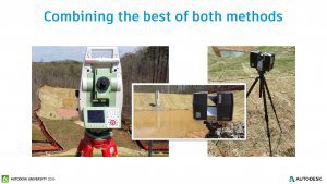
Survey control points can be as simple as a stake driven into the ground with a target sphere on the top, which can then be used to anchor point clouds accurately. For insider tips and to explore visualization techniques, check out Young’s AU 2016 class—available free through AU online: Georeferenced Point Clouds into AutoCAD Civil 3D Surfaces. (AIA Approved)
Take Flight
When surveying an active construction site, taking to the air can help you get the job done. Andy Thoma, BIM manager for Grunley Construction, discovered the aerial advantage on a large-scale, occupied construction site. Thoma and his team needed to design a haul road to remove demolition without impacting the site, impeding construction, or disturbing other elements such as landscaping and underground utilities: “The road is continuously changing, so we needed a way to survey the data and create a digital terrain model to understand how the material’s going to move.”
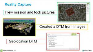
Using drones enabled Thoma’s team to locate a site and obtain a topography survey, from which they were able to design a haul road that balanced to zero. Thoma spoke about this use case, including requirements and how to overcome aerial survey challenges to create consistent, reliable earthwork data, in this AU 2016 class: Balancing with Drones: Using UAVs for Site Balancing and Haul-Road Design. (AIA Approved)
Better Plans, Better Results
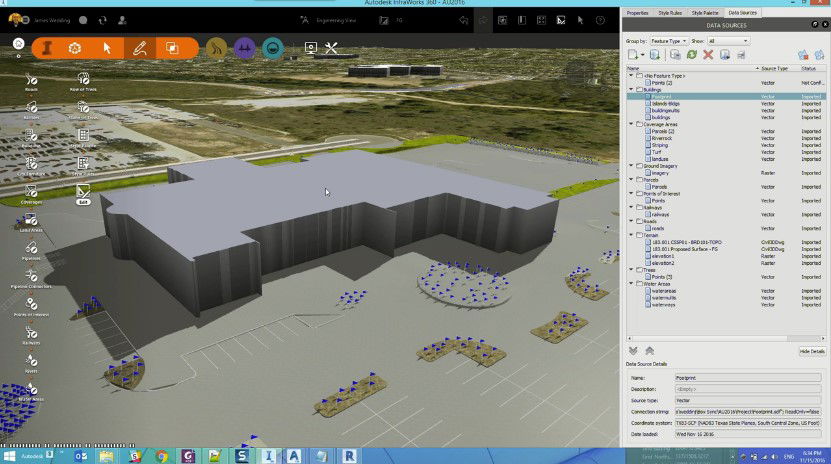
Using BIM on large-scale infrastructure projects can enhance collaboration by combining data from multiple sources into a singular model. BIM models have the added advantage of being easier for clients to understand than traditional site plans, such as survey data or engineering plans. Autodesk Inc. Infrastructure Solutions Specialist James Wedding says, “We have to communicate with people who don’t read contour maps.”
Wedding recommends using Autodesk InfraWorks 360 software to convert “boring site plans” into fully realized 3D models that will impress everyone—including your clients. To learn how to bring AutoCAD Civil 3D, Revit, and other design data into InfraWorks 360 to make site plans and linework “pop,” and create “before and after” site design images for added impact, grab a (virtual) seat in Wedding’s AU 2016 class: Don’t Bore Me with Your Site Plan! (AIA Approved)
It’s All about the Data
When making the leap to BIM, customizing data attribution requirements will help you get the most value out of every dataset. According to Lucy Kuhns, AEC/ENI solutions and support engineer for Autodesk Inc., “It’s a requirement for BIM readiness—especially for infrastructure. When that data has attribution, then it’s smart. It has dynamic behavior.”
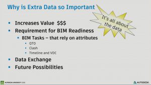
There are many tools and methods available to help you customize data attribution to streamline infrastructure workflows—you just have to know how to use them. Kuhns explains four distinct methods in depth in her AU 2016 class: The Data Lab—How to Link, Extract, Customize, and Extend Data for BIM Readiness. (AIA Approved)
If you’re ready to give your next infrastructure project a boost, AU online (au.autodesk.com) and the AU community offer thousands of free resources and practical advice on BIM technology and processes that you can use to learn on your own, anytime.

Todd Danielson
Todd Danielson has been in trade technology media for more than 20 years, now the editorial director for V1 Media and all of its publications: Informed Infrastructure, Earth Imaging Journal, Sensors & Systems and Asian Surveying & Mapping.
Video: Crashes Drop Measurably After Rural Road Safety Improvement Project on US 521 in Lancaster County

AdventHealth Weaverville Hospital

June Issue 2026
.jpg?width=225)