
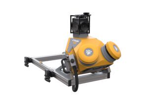
Vehicle-Mounted System Enables Data Capture for Road Agencies and Local Governments SUNNYVALE, Calif.— Trimble (NASDAQ: TRMB) introduced today the Trimble® MX50 mobile mapping system for asset management and mapping—a new addition to its established…
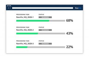
NavVis Introduces Processing in the Cloud for Even Faster Laser Scanning Workflows
From processing to viewing, with NavVis it can now be done entirely in the cloud. Munich, Germany – NavVis, an innovator in indoor mobile mapping,…

Collect Data Once, Use Whenever Needed: Mobile-Mapping Systems Create Quick and Detailed 3D Models of Infrastructure
Complete mobile-mapping systems combine sensory information into 3D models that include point clouds, imagery and geolocated data that can be used for…
