
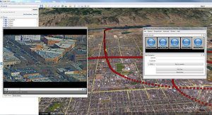
FORT COLLINS, Colorado – Remote GeoSystems, Inc. is pleased to announce the release and availability of the all new LineVision™ Google Earth Extension – commercial software for UAV, airborne & terrestrial mobile inspection and survey projects requiring…

TomTom’s HD Map Powers Autonomous Driving
MELBOURNE, Australia - ITS World Congress – TomTom (TOM2) today announces a joint autonomous driving demonstration with Bosch. TomTom provided its HD…
Woolpert Earns Google for Work Premier Partner Status
DAYTON, Ohio, July 28, 2016 — Woolpert has attained Google for Work Premier Partner Status, an elite designation achieved by reaching sales benchmarks…
