

Qognify adopts Hexagon’s corporate identity, signalling a strong future of innovation and added value for customers (HUNTSVILLE, Ala., 4 April 2024) –Hexagon’s Safety, Infrastructure & Geospatial division announced Qognify, a leading provider of…
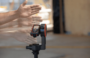
Leica Geosystems launches two new DISTO™ laser distance meters with gesture-triggered readings
Leica Geosystems, part of Hexagon, has introduced two new top-of-the-line handheld laser distance meters: the Leica DISTO™ D5 and DISTO™…

Hexagon partners with Nemetschek Group
(Stockholm, Munich, 26 March 2024) Hexagon's Geosystems division and the Nemetschek Group, a leading software provider for the AEC/O and media industries,…
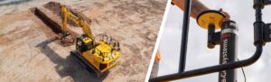
New Factory-Fitted Machine Control Solutions Launched
JCB and Leica Geosystems are joining forces to offer factory-fitted 2D and 3D-ready semi-automated excavator control solutions. (Heerbrugg, Switzerland, 20 03 2024) JCB and Leica Geosystems, part of Hexagon, today announced that they are joining forces…

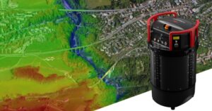
IDS GeoRadar launches Chaser XR ground-penetrating radar
The new compact and lightweight ground-penetrating radar solution for subsurface profiling extends the power of revolutionary Equalised scrambled Technology to geophysical surveying. (PISA, Italy) IDS GeoRadar, part of Hexagon, today announced the launch of…
Hexagon partners with Sony Semiconductor Solutions to enhance reality capture
Providing customers with seamless workflow and instant data capture and processing Hexagon AB, the global leader in digital reality solutions combining sensor, software and autonomous technologies announced the partnership with Sony Semiconductor Solutions…
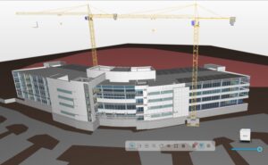
Hexagon introduces cloud-based HxGN AEC Project Viewer to connect office and field in real time
Las Vegas, Nevada: Hexagon's Geosystems division today announced the launch of HxGN AEC Project Viewer, an innovative, cloud-based software to visualise, federate and control project data easily. Construction projects involving multiple stakeholders often…
Leica Geosystems introduces Leica CountryMapper, the world’s first hybrid imaging & LiDAR sensor for large-area airborne mapping
Setting new productivity standards in the airborne mapping industry Bringing unprecedented efficiency and data quality to large-area aerial data collection (Heerbrugg, Switzerland) Leica Geosystems, part of Hexagon, introduces the Leica CountryMapper,…

Hexagon launches Reality Cloud Studio to bring automated digital reality to the cloud
With automated processing and visualisation tools, Reality Cloud Studio makes digital twins accessible to everyone Stockholm, Sweden – Hexagon AB, the global leader in digital reality solutions combining sensor, software and autonomous technologies, today…

Hexagon introduces A8V MIND, an industry-first for precision mobile surveillance
(Heerbrugg, Switzerland, 08 June 2023) Hexagon’s Geosystems division today announced a portable version of its Accur8vision detection system. A rugged all-in-one solution, the A8V MIND (Mobile Intrusion Detection) is designed to provide flexible…
