

Mobile LiDAR scanners are mapping underground spaces in Belfast to better understand and prepare for coastal flooding. The use of innovative technology provides greater clarity of large flood risk areas for surveyors, through the creation of flood models.…
Georeferencing takes center stage for GeoSLAMs latest software release
Enhancements to georeferencing workflows have become the main focal point of GeoSLAMs latest software release, Connect 2.3. The release includes improvements…
Colourisation and immersive walkthroughs among major GeoSLAM updates
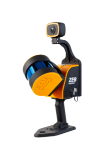
GeoSLAM has announced the official launch of its ZEB Vision 4K panoramic camera which allows users to capture and process colourised data faster than…

New GeoSLAM Hardware and Software Revolutionises SLAM accuracy and automation
GeoSLAM launches its latest software offering Connect 2.0 at Intergeo. Connect 2.0 brings industry-leading accuracy to ZEB range of handheld scanners. The next generation SLAM algorithm, GeoSLAM Beam, powers new software. ZEB Vision, a new solution for colourisation…

GeoSLAM launches next generation data processing
Market leaders in mobile SLAM technology, GeoSLAM, is bringing automation to the industry, with the launch of GeoSLAM Connect. Connect is an automated processing platform that provides users with the flexibility to process their data to their exact specifications…
GeoSLAM Completes Spook-Tacular Scanning of Californian Landmark
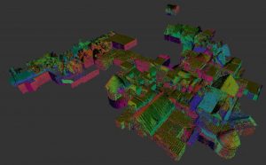
The team at geospatial 3D mapping specialist GeoSLAM has produced a digital twin of one of the world’s most haunted mansions, The Winchester Mystery House, using the newly-launched ZEB Go. It may be hard to believe the feat of scanning this vast architectural…
