

No-code integration empowers planning and construction teams with essential construction intelligence extracted in near real-time from survey-grade reality captures. YOKNEAM, Israel – Datumate, developer of the DatuBIM Construction Data Analytics platform,…

Colorado DOT Has Adopted Datumate’s Cutting Edge Mapping Tools
YOKNEAM ILLIT, Israel - Datumate's professional Site Survey Solution has helped the Colorado Department of Transportation (CDOT) to quickly and safely…

DJI and Datumate Launch Designated Site Survey Solution Bundles for Field Construction, Surveying and Infrastructure
DJI and Datumate launch an upgraded Site Survey Solution bundles with industry specific capabilities for field construction, surveying and cellular infrastructure…

Datumate Announces Designated Solutions for Survey, Construction and Infrastructure Companies
YOQNEAM, Israel - Datumate expands its photogrammetry software and drone app portfolio aimed at targeted needs of Construction, Surveying and Infrastructure companies worldwide. The comprehensive Site Survey Solution includes professional imagery and mapping…

DJI and Datumate Partner to Deliver Site Survey Solution
DJI and Datumate have begun offering a drone, software and app package that fully automates and expedites site surveys. Tailored for professional surveying jobs, the DJI-Datumate Site Survey Solution simplifies the surveying and mapping processes, while maintaining…
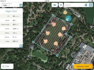
Datumate Unveils DatuFly, A Professional Imagery App for Drones
YOQNEAM, Israel, September 6, 2016 - Datumate, a market leader of automated "Field-to-Plan" solutions that save costly field and office time, is pleased to announce a new tablet app for effortless drone flight planning and automated, high resolution photo-shooting.…
