
Land to be used for a housing development in Silverthorne, Colo., was originally homesteaded in the 1860s as ranch land for hay production and grazing Scottish Highland cattle. Although the ranching tradition continues on the property, a portion was recently…

Infrastructure Outlook: From the Video Vault: Erosion Control
Informed Infrastructure spoke with Matthew Welch, technical manager with Profile Products, at the International Erosion Control Association (IECA) Environmental…

Executive Corner: “I Know that E-mail’s Here Somewhere”
Understanding professional liability and managing risk is an important aspect of all A/E projects. For this installment of “Executive Corner,” Russ…
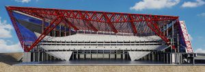
Infrastructure Showcase: Autodesk AEC Excellence Awards Winners
At Autodesk University 2016 in Las Vegas, the company presented its AEC Excellence Awards. This year’s competition showcased projects embracing the future of making things for AEC and civil infrastructure through the use of innovative and connected BIM technologies,…

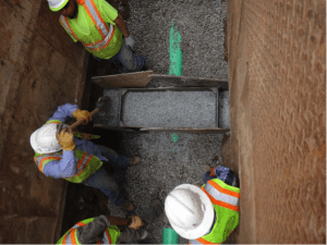
Infrastructure Showcase: Co-Winners of the 2016 Sidney Freedman Craftsmanship Award
The Precast/Prestressed Concrete Institute (PCI) announced co-winners of the fifth annual Sidney Freedman Craftsmanship Award, which recognizes PCI-certified plants for excellence in manufacturing and craftsmanship of architectural precast and glass fiber-reinforced…
November – December 2016 TRENDS
In this section, Informed Infrastructure compiles infographics from trusted sources that reveal insight on infrastructure spending. We also compile some of the top infrastructure stories that shouldn’t be missed.
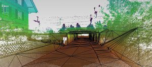
Collect Data Once, Use Whenever Needed: Mobile-Mapping Systems Create Quick and Detailed 3D Models of Infrastructure
Complete mobile-mapping systems combine sensory information into 3D models that include point clouds, imagery and geolocated data that can be used for mapping, understanding current topography and infrastructure asset management.

Final Thoughts: The Tools Are Nothing Without the Engineer
In the September/October 2016 issue of Informed Infrastructure, I described showing up for my first day of work back in the early 1970s with my slide rule, mechanical pencil and scales. If I were to start working today, fresh out of college, I wouldn’t have…
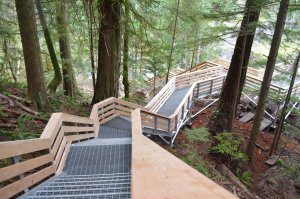
A Scenic, Secure Thriller: Elk Falls Park Suspension Bridge Provides Sensitive Access to Canadian Treasure
By Angus W. Stocking, L.S. Elk Falls, beautifully cascading for 89 feet (27 meters), is the centerpiece of Elk Falls Provincial Park on Vancouver Island. By all accounts, it’s one of Canada’s most-scenic waterfalls, but for most of the park’s existence,…

From the Editor: Celebrating the Work We Do
Timing is everything, and I couldn’t have timed my joining Informed Infrastructure any better. The AEC industry continues to grow at a rapid rate, and the key technologies such as BIM, reality capture and even virtual and augmented reality are finally growing…
