

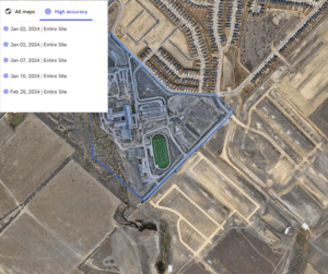
andsat Explorer Makes Longest-Running Continuous Satellite Imagery More Accessible for Decision-Makers REDLANDS, Calif.—February 13, 2024—Esri, the global leader in mapping and location intelligence, announces the launch of Landsat Explorer, a groundbreaking…
Trimble and DroneDeploy Introduce Premier Positioning Accuracy and Streamlined Workflow for Reality Capture from Drones
RTX-based cloud positioning service expands project opportunities for drone mapping DENVER – GEO WEEK (Booth# 1001) – Trimble (NASDAQ: TRMB)…

DJI Launches Its First Intelligent 3D Model Editing Software DJI Modify
Makes repairing common 3D model defects simple and efficient January 18, 2024 – DJI, the world’s leader in civil drones and creative…

Trimble Introduces MX90 Mobile Mapping System
Trimble announced today the leading-edge Trimble® MX90 mobile mapping system. With state-of-the-art Trimble GNSS and inertial technology, when combined with Trimble field and office software, the Trimble MX90 provides a complete field-to-finish mobile…

Exyn Unveils Nexys: A Fully Modular 3D Mapping Solution for Complex and Challenging Environments
GEOWEEK, FEBRUARY – Exyn Technologies, a pioneer in autonomous robotics, today announced the launch of Exyn Nexys, a revolutionary modular 3D mapping solution. Designed for professionals in mining, construction, AEC, and geospatial industries, Nexys sets…

A New Standard for Material Testers: ‘Connected CMT Machines’ Promise Speed, Accuracy
Does your machine 'know' what it's testing? Forney introduces Connected controls to renowned fleet of construction materials testing machines. ZELIENOPLE, Pa., February 6, 2024-- Forney LP, the leading manufacturer of construction materials testing (CMT) machines,…

Autodesk Informed Design Unlocks Industrialized Construction to Connect Design and Make Workflows
Autodesk launches Autodesk Informed Design to unlock industrialized construction for building design professionals and manufacturers. Autodesk Informed Design connects design and make workflows from day one, to streamline the building design and construction…
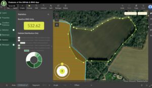
New Esri UK partner Temple creates biodiversity net gain assessment tool
Streamlined workflow helps users meet England's new legislation Temple, one of the UK’s leading environment, planning and sustainability consultancies, has joined the Esri UK partner network as a Silver Partner. The new partnership enables Temple…

Trimble Announces Three New Products
Trimble SiteVision Software 5.0 is the latest version of the company’s high accuracy outdoor augmented reality system, now with a new 3D scan tool. The 3D scan app allows customers to use LiDAR sensors available on some Apple Pro devices to capture…
Sika’s Rmax® Introduces Below-Grade Insulation Solution
Innovative Polyiso Insulation Meets All Performance Requirements With 25% Less Material LYNDHURST, NJ — Rmax®, a division of the Sika Corporation that specializes in developing and producing high-quality insulation solutions, has launched Rmax®…
