Leveraging Bentley Technology Shortens Delivery Schedule and Reduces Implementation Costs Amid Difficult Terrain and Failing Infrastructure
Urbanization for Informal Settlements
The Rwanda Ministry of Infrastructure retained Voyants Solutions (Voyants), as part of a consulting consortium to help facilitate the government’s master plan to modernize Rwanda’s infrastructure. Aligned with its vision to sustain more diversified and resilient sources of growth and increase urbanization from 19 to 35 percent by 2020, the government initiated a USD 10 million project that required Voyants to conduct a feasibility study assessing the existing environmental and community conditions. The project also necessitated the delivery of preliminary designs for proposed sustainable solutions to regenerate six secondary cities in the Agatare area of Kigali. The planning and development project includes upgrading 86 square kilometers of informal settlements that accommodate more than 18,000 residents in 3,977 households within the Agatare region.
Bentley visualization applications’ simple data transfer capabilities improved collaboration and enhanced image quality.
Facing Critical Conditions
A residential housing community with small commercial shopping areas surrounded by wetlands, Agatare is situated amid hilly, steep sloping terrain subject to flooding and erosion. The community also faces safety, critical road access, drainage, sanitation, and solid waste management issues. Most housing is located on slopes greater than 30 percent and the homes face significant danger of collapsing during heavy flooding. Upendar Rao Kollu, managing director for Voyants, said, “460 structures are at risk of collapsing, 70 percent of houses have no vehicular access, and footpaths are dilapidated and eroded.” Heavy rain severely impacted the drainage system, erosion and flooding caused some drains to be choked with silt, and other storm drains were fully destroyed.
To add to the complexity of the situation, poor sanitation and solid waste management facilities posed health risks to the people and the surrounding environment. Only 7.1 percent of residents were using flushable toilets, and although many households were disposing of waste through a waste collection company, many still dumped waste in exposed areas, along open drains, and in the wetlands. Faced with these challenges and a six-month schedule, Voyants needed accurate, integrated technology to compile a feasibility study that prioritized projects to improve drains, roads, and environmental management, and determined the best approach for urban planning and development in the region.
Integrated Technology Facilitates Inclusive Feasibility Study
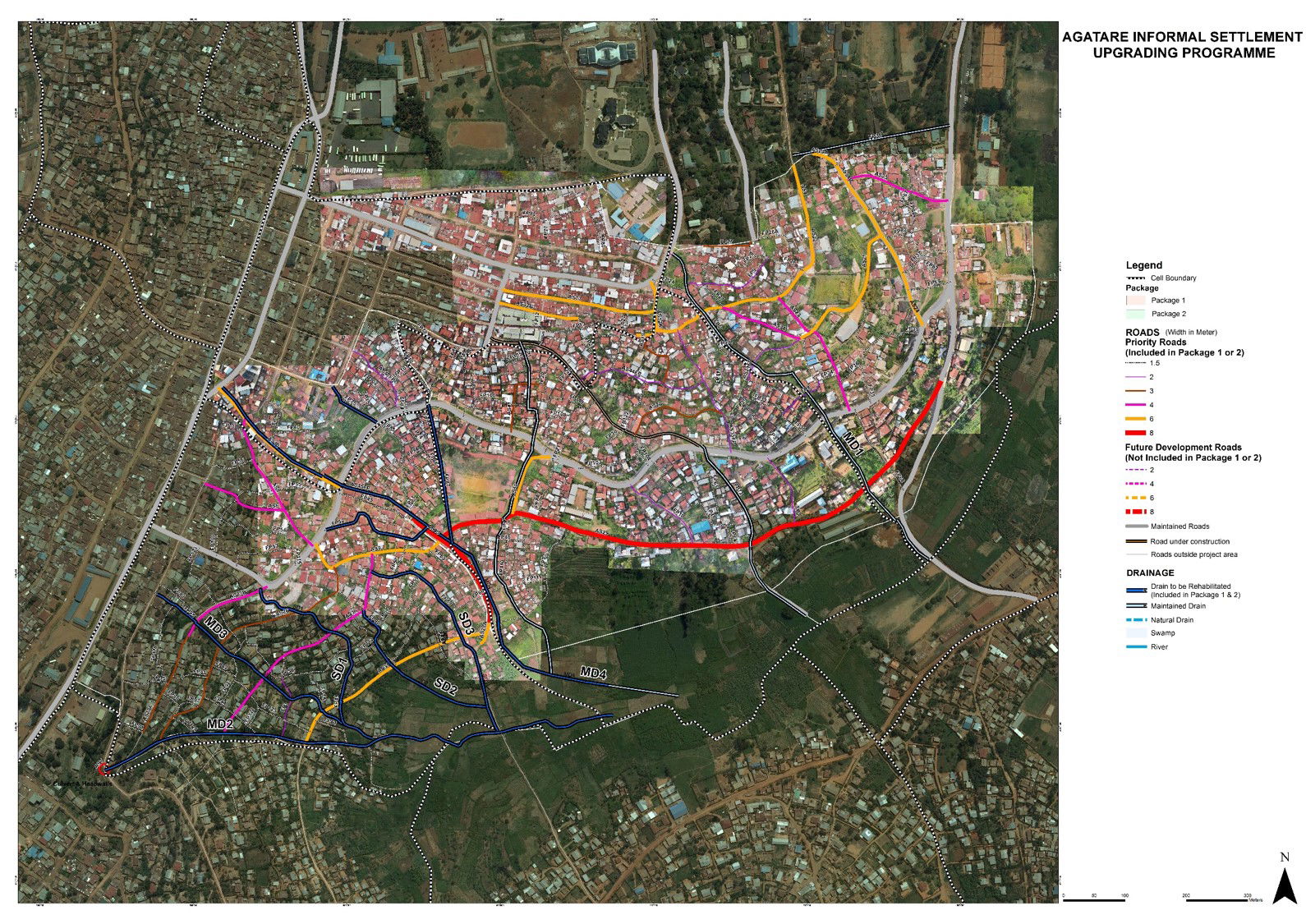
To overcome the obstacles and execute a comprehensive feasibility study, Voyants used Bentley Map, OpenRoads Designer, and StormCAD to enhance the roadways and improve drainage. The project team conducted spatial analyses using survey and drone technology. Then, using Bentley’s GIS and mapping software, Voyants combined engineering data and digital imagery to create accurate 3D information models for use in modeling and analysis. “We compiled all this information into a property-based map,” Kollu explained.
Relying on Bentley’s interoperable technology for planning, design, and survey works, the project team mapped existing features, addressed road access and connectivity, and assessed the drainage issues to effectively conduct its feasibility study. Voyants evaluated the impacts of the environment and proposed sustainable solutions to improve the health, safety, and general welfare of the community and the surrounding environment. Furthermore, to help prioritize projects, Voyants consulted with community households to determine their needs for an integrated approach to infrastructure planning and development.
Leveraging Bentley Applications Improves Collaboration and Efficiencies
Bentley mapping and modeling applications allowed for the seamless transfer of digital images and design data, improving collaboration, information mobility, and quality of deliverables across the project team. Bentley products’ ability to accommodate various file formats was instrumental in enabling Voyants to complete the study ahead of schedule by eliminating the time it would typically take to convert the project files. “We were given six months time to complete the project, and we completed it in five months,” stated Kollu.
The team was able to identify and present decision makers with effective solutions, allowing authorities to reduce costs for land development planning because of Bentley applications’ accuracy and efficiency. Leveraging Bentley technology, Voyants reduced resource hours by 20 percent and cost of services by 15 percent. Upon completion of the project, Voyants expects to realize a total ROI of up to 14 percent.
“On this integrated infrastructure solution project, Bentley [technology] was of great help to us and we are using almost all Bentley models in all of our projects,” Kollu said.
Successful Pilot for Future Urban Regeneration
Using Bentley technology throughout project planning and design facilitated the delivery of a feasibility study for the development and urbanization of the Agatare informal settlements that, once implemented, will improve living conditions of more than 18,000 residents in the area. As a result of the proposed solutions in the study, the Agatare region will see enhanced connectivity and relief from flooding with upgraded roads and storm water drainage systems. These improvements reduce the risk of disease and the negative environmental impacts associated with flooding and poor waste management.
Overall, the redevelopment project will help create off-farm jobs and improve institutional support for urban management of the area in alignment with Rwanda’s Vision 2020 plan to achieve development targets in urbanization. Offering sustainable solutions for local economic development and infrastructure improvement, the Agatare informal settlements regeneration plan will serve as a pilot for community-based urban regeneration in other areas of Kigali City.
Voyants utilized Bentley technology to analyze roadways and drainage systems in Agatare, Rwanda as a part of an all-inclusive feasibility study.
Project Summary
Organization: Voyants Solutions Pvt., Ltd.
Solution: Land Development
Location: Kigali, Nyarugenge, Rwanda
Project Objectives:
Support Rwanda’s Vision 2020 plan to improve living conditions and promote local development in six secondary cities of the Agatare region of Kigali.
Conduct a feasibility study to assess current infrastructure and prioritize urbanization projects in Agatare.
Provide designs for sustainable infrastructure solutions in Agatare that will serve as a pilot for future community-based urban regeneration that can be scaled to other towns.
Products used: Bentley Map, OpenRoads Designer, and StormCAD
FAST FACTS:
Voyants was a part of a consulting consortium conducting the study, funded by a grant through Rwanda Ministry of Infrastructure.
Voyants used Bentley applications to overcome environmental challenges and sloping terrain.
Bentley software analyzed environmental impacts and new solutions were proposed to address erosion, connectivity, safety, and health issues.
ROI:
Implementation costs were reduced, resource hours were cut by 20 percent, and the study was completed one month ahead of schedule.
Residents benefited with enhanced connectivity and improved drainage and waste management.
“Bentley is the solution for integrated infrastructure development.”


.jpg?width=225)