
I know what you might be thinking: “Yawn. Another story about drones. Skip!” and usually I’d agree with you. There are so many stories, so much marketing, and so much hype around drones that it’s easy to get bored with the topic. However, it’s with this sentiment in mind that I decided to write something about drones you can use in your business. I spent time with a group that has taken drone-based reality capture from the “wow” phase to a practical, profitable business.
The team of Region Engineering and Surveying (www.regiondesignllc.com), along with sister company RealityOne (R1), has quickly become the leaders in unmanned aerial vehicle (UAV) data capture throughout the western United States. After seven years in business as a traditional survey and engineering firm, Region created a new brand of services that focuses strictly on reality capture in the form of light detection and ranging (LiDAR) scanning and UAV/drone capture. Together, Shawn Herring and Brandon Monsen formed RealityOne and quickly “captured the ground by taking to the skies.”
“This has been an incredible adventure,” notes Monsen, RealityOne’s co-founder and senior chief pilot in command. “From the beginning, Shawn and I decided to push the limits of reality capture and set the new standard for the survey industry.
“There’s a revolution underway in the surveying industry: drones have finally matured to the point where they’re saving time and money on projects of all sizes,” he adds. “Not only are drones used for still-shot photos and videos, but they have now become the go-to tool for topographic surveys of all kinds. This technology goes far beyond choosing which aircraft is right for you. It’s about choosing the proper workflow and looking for a complete drone platform that meets your specific needs.”
More than the Drone
A complete drone platform is a combination of the actual drone, proper analytics software and the support you need to get off the ground. But how does a survey drone work? What type of data can it collect? What’s the workflow? What’s the return on investment (ROI), and who has implemented drone solutions successfully? And, most of all, where do I start?
Region/R1 has a fleet of drones and attempts to utilize “the right tool for the right job” at all times. The team deploys drones from DJI (Phantom 4 Pro and M200/210 series) and multiple Site Scan Drones from 3DR—each have their own strengths and weaknesses. On many flights, they have up to four drones in the air at the same time capturing data. For all its flights, data sharing and data storage, the team uses 3DR’s Site Scan software, which uses multiple processing engines from Autodesk as well as Pix4D.
A SUMMARY OF SITE SCAN SOFTWARE
Site Scan, a fully automated aerial analytics platform from 3DR, consists of three main components:
1. Data Collection, which works in three different capture modes:
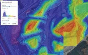
3D Model Scan Mode. After selecting the object to be modeled, Site Scan creates a flight path to orbit the object, collecting all necessary images, and stitches them together to form a complete 3D model.
Survey Mode. After selecting the area to be surveyed and the desired resolution, Site Scan executes a flight path to capture data and then applies geotagging, orthorectification and stitching.
Inspection Mode. In this mode, high-resolution capture of objects to be inspected is controlled via simple “pinch and swipe” gestures similar to those used when viewing pictures on a smartphone.
2. Data Processing. After collection, data can be uploaded to the 3DR Cloud and Autodesk ReCap for further processing, readying the data for integration into other design applications.
3. Cloud Integration. Site Scan integrates with cloud analytics systems, allowing for ready consumption by a wide range of products for various uses.
“The first step in any successful drone survey is proper mission planning,” says Herring. “We always come up with a well-thought-out flight plan prior to getting onsite, which helps us streamline target location and setting as well as ensure we cover the proper areas in the most-efficient time. Using the Site Scan Field app, you can quickly map out the area you want to survey by placing a polygon over the desired area and adjusting it as you please. Site Scan will automatically create the flight path to most effectively cover the area of interest.”
There are a few key considerations in flight planning: flight altitude, estimated flight time, ground sampling distance (resolution in inches per pixels), survey area in acres, number of photos that will be captured and number of batteries required. These will vary depending on the unique needs of the job and the size of the survey site.
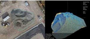
A Sony R10C camera, which is on the 3DR Site Scan drone, exceeded the standards of the Registered Professional Land Surveyor and provides top-notch accuracy. Region also sets a minimum of five ground-control points throughout the site—no matter the size—and uses them to georeference their orthomosaic and ground topo. On a recent 300-acre topo, Region placed 40 targets at strategic locations throughout the site. They have customized targets for easy use in the field, so they can quickly get the targets on the ground and the drones in the sky.
STEEL MILL SURVEY DATA
Project Name: Geneva Development
Project Location: Vineyard, Utah
Project Size: +/-600 acres
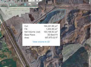
Project Description: The Geneva Development Site in Vineyard, Utah, used to be one of the largest steel mills in the country. Since its closure about 15 years ago, extensive measures have been taken to reclaim the site and bring it up to Environmental Protection Agency (EPA) standards for future growth. Region Engineering and RealityOne were contracted to capture survey data for the entire site, get an up-to-date orthoimage and calculate millions of cubic yards worth of materials.
UAV Services Provided
• Topographic survey +/-0.10-foot accuracy
• Stockpile volume calculations
• Existing foundation mapping
Project Capture Statistics
• Set/surveyed 40 aerial targets tied to NAD83 survey control
• Deployed three drones to capture all 600 acres in less than four hours of total flight time
• Utilized Site Scan to manage and process flight data and per- form volumetric calculations
• Minimized total site time to one full day, saving a total time of nine additional survey days vs. traditional methods
• Delivered a better end product at a fraction of the time and cost
• Total time savings of approximately 15 times compared to other methods of capture and calculation
• Design applications (e.g., Civil 3D) not needed—all work completed within 3DR Site Scan
Unique Advantages
UAVs offer incredible advantages that aren’t readily available otherwise. The ability to “fly on demand” (in the proper airspace) gives users the flexibility to survey sites much faster as well as survey terrain that might not otherwise be accessible. This technology also provides the ability to fly a site as often as needed. Currently, Region/R1 is involved with several projects in which flexibility and weekly data are extremely beneficial.
“Construction updates, material stockpiles and project feasibility analysis all are incredible benefits of flying on demand that are less intrusive and much safer for our field crews,” says Herring. “We can be stationary onsite, not moving in and around heavy machinery.”
Region/R1 also uses additional resources to make the most out of their aerial surveys. They call in “bluestakes” (underground utility locations and markings) prior to flights to paint the underground utilities. They also take the time to paint their own measurements on gravity mains such as sewer and storm drains. They found this to be very beneficial for their backoffice design and drafting teams, often finding data that typically may not be captured in traditional surveys, which can cut costs by eliminating additional site visits.
“We use the image more than we ever thought,” adds Herring. “It isn’t just a pretty picture; it’s an as-built of pre-existing conditions prior to design.”
NEW-SITE DEVELOPMENT
Project Name: Reynolds Construction – Reynolds Truck Center
Project Location: Orem, Utah
Project Size: +/-4 acres
Project Description: The Reynolds Truck Center in Orem, Utah, was a small 4-acre new-site development. Region Engineering and RealityOne were contracted to capture survey data for the entire site, perform an ALTA survey and monitor several construction tasks.
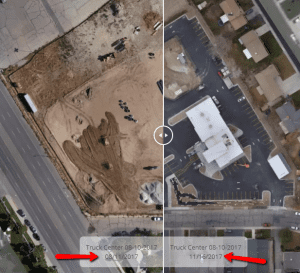
UAV Services Provided
• ALTA/topo survey
• Construction progress monitoring
• Material volume verification
Project Capture Statistics
• Set/surveyed six aerial targets tied to NAD83 survey control
• Painted “bluestakes” for all underground utilities and measure-downs
• Weekly flights for construction updates
• Material volume calculations
• 5x time and cost savings over traditional ALTA method
A New Tool in the Toolbox
Region/R1 has performed many American Land Title Association (ALTA) surveys, and the data captured via drone is a major benefit to them and their clients. Being able to map out parking, Americans with Disabilities (ADA) stalls/ramps and other items that are time consuming to capture in the field is another way they continue to save time and money.
On a recent ALTA survey of four acres, Region/R1 reduced costs 80 percent compared to traditional methods. The site was littered with heavy machinery and materials, and the client requested that they not be on the ground during typical work hours. This was an easy challenge for Region/R1 to overcome by first finding an unobtrusive staging area outside the heavy traffic area, which allowed them to capture all the data needed, in a fraction of the time, without disrupting the work crew’s daily workflow.
For traditional surveys of more than five acres, Region/R1 reduced data capture time by more than 10 times compared to traditional surveying. They also can pick up a lot more data, ensuring they have the most-accurate product possible. They now fly drones on every project, even if only for the orthoimage used by their engineering team on most land-development projects.
“This is not a replacement for traditional land surveying, this is simply a new tool in our toolbox,” says Herring. “Our survey crews are more important than ever and ensure we have met or exceeded industry standards for accuracy and data capture. This allows for more time in the office to properly certify boundaries and other legal information. Survey has changed drastically in the last 50 years, and this is just the latest change. We have gone from total stations to GPS to robotic stations, and now scanners and drones.
“Getting into the drone world was going to happen for us no matter what,” adds Herring. “We have put these drones through many tests, and they have earned their place in our business.
“But investing with 3DR and Site Scan as a full platform solution is the best decision our companies have made, and we look forward to progressing alongside them,” he concludes. “We are proof that even the smallest companies can compete by investing in the latest and greatest technology.”
Project Name: Shamrock Farms – Big D Construction
Project Location: Phoenix
Project Size: +/-22 acres
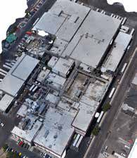
Project Description: Shamrock Farms was founded in 1922 and is one of the largest family owned and operated dairies in the United States. The Phoenix factory has major expansion plans, and Region Engineering and RealityOne were contracted to capture supplemental LiDAR scan data with exterior UAV data.
UAV Services Provided
• Exterior data capture of buildings/piping systems
• Site data capture (point cloud and image) for possible future expansion
Project Capture Statistics
• 1 hour onsite flight time
• Captured as much data as 5 days worth of exterior LiDAR scanning
• Accuracy captured at +/-3 inches on buildings and aboveground piping systems
• First true as-built at this factory site
• 4x time and cost savings compared to traditional scan/process

Mark Scacco
Mark Scacco, P.E., is a 25-year veteran of AEC technology and design consulting. He is an AEC Industry Consultant with Scacco LLC and can be reached via email at [email protected].
Video: New Roundabout Under Construction at McIver and Old Florence Roads in Darlington County

Bridge Replacement at Amsterdam Centraal Station

June Issue 2026
.jpg?width=225)