
Graz, Austria — May, 2017 — Vexcel Imaging is announcing the new UltraCam Panther, a versatile portable platform that carries complementary sensors to capture full-spherical imagery and video, dense 3D LiDAR point clouds and precise trajectory information in both indoor and outdoor environments.
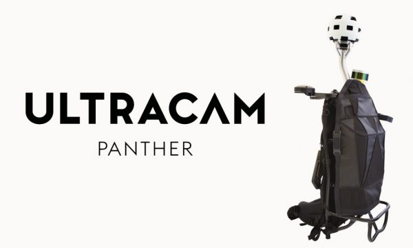
The UltraCam Panther’s panoramic head holds 26 cameras to capture very high resolution still imagery or video with a 360-degree field of view. A multi-beam rotating LiDAR sensor simultaneously collects precise 3D data. A visual odometry sensor offers a custom-built software solution that delivers uninterrupted accurate trajectory data in challenging environments where no GNSS signals are present.
The platform’s modular design allows the system to be equipped with sensors offering differing capabilities to accommodate each customer’s needs. All sensors are synchronized and timestamped, resulting in precise registration between the LiDAR data and imagery.
“As a portable 3D mapping and reality capture system, the UltraCam Panther is suitable for indoor, outdoor and underground use,” said Alexander Wiechert, CEO of Vexcel Imaging. “It offers outstanding flexibility for mapping and virtual reality applications through its technical performance in the areas of image quality, video performance, accuracy and ease of use.”
A variety of customers have expressed an interest in the UltraCam Panther, with possible applications including insurance, cultural heritage, construction, tourism, engineering, virtual experiences and indoor building information modeling (BIM).
“Vexcel Imaging focuses on producing top quality products that meet the diverse needs of our markets around the world,” said Wiechert. “In this case, the ability to collect very high-resolution photogrammetric-grade images and video, georeferenced with dense LiDAR point clouds, makes the UltraCam Panther a distinctive mobile mapping platform.”
About the UltraCam Panther
The UltraCam Panther features include:
• Full panoramic coverage with imagery, video and LIDAR data
• Precisely georeferenced data products independent of GNSS reception
• Dense 3D point clouds from multi-beam LiDAR
• Geometrically calibrated and time synchronized sensor rig
• Modular concept allows customization to meet varying needs
• Portable and ruggedized design for use in a wide range of Environments
