The economic downturn impacted many nations around the world including the US. In particular, decreasing home values left many Americans underwater on their mortgages and many companies and organizations struggling to survive. Companies downsized or went out of business altogether, leaving many out of work. The impact was far-reaching and is still being felt across most of the nation and many other regions, such as the EU, which suffered even far more devastating consequences.
As our country continues it’s slow but steady climb out of the down economy, we can look back and see some positive signs that ensued in the process. For example, as part of President Obama’s economic recovery programs, significant capital investments were allocated for transportation and infrastructure improvement programs.
Understanding Impacts
When such large transportation or infrastructure projects are funded and approved, serious and thoughtful planning and implementation need to be done. These plans are intended to achieve desired future conditions defined by the community through eliminating the loss of property value or decreases in quality of life for existing residents across various socioeconomic divides. They also need be sustainable. This means ensuring that ecosystems aren’t destroyed or disrupted. For this to happen, the location of any new project must be analyzed and determined based on factors that take into account the financial aspects as well as the environmental and social considerations.
It is crucial for planners, however, to understand the impact of these development proposals on various aspects of life on both the local and region scales. Location of any construction is key in determining what makes sense in terms of development potential for any community. The ability to visualize community assets, environmental constraints, and demographic and socioeconomic data on a map makes it possible for planners and community developer to identify the best locations of new construction, how these projects should look, and what impact they will have on the community. The bottom line in all of this is that capital improvement projects should be placed strategically in certain locations in order to optimize and maximize its use towards the advancement of the overall quality of life for all residents.
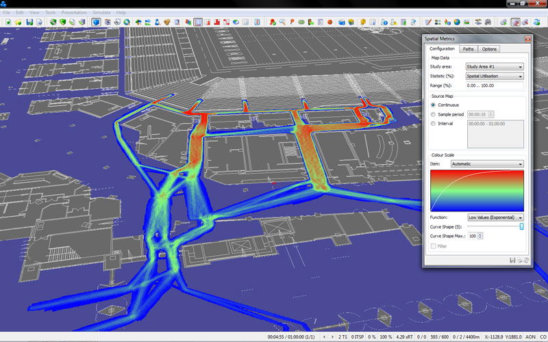
Visualization, with color scales for traffic intensity, give planners and the public more detailed insight into interactions. Image courtesy of Quadstone Paramics, a Pitney Bowes company.
Smart Planning
Geospatial data and location intelligence solutions are critical elements in the advancement if smart planning because they are capable of capturing, managing and visualizing large amounts of data, including requests from the public and various community groups and stakeholders. The ability to understand the context within which any project is being placed can be done by conducting evidence-based analysis, generating viable scenarios and visualizing new developments on a map. This will ensure that all of these new development proposals allow healthy future growth that is economically viable, socially acceptable, and environmentally sound and sustainable. When planners utilize location intelligence solutions, better, more informed decisions can be made and the laborious and longwinded planning process can be significantly expedited by advancing the development into the design, build and management stage much faster and more efficiently.
Engaging Stakeholders This is great, if it all was conducted in a vacuum. However, when it comes to development planning, there are many stakeholders. To ensure that development is truly responsible today and sustainable for the future, it’s important to give all of stakeholders a voice in the process from its very onset.
Whether they’re local homeowners with complaints about the impact that new development will have on traffic patterns, or the local Board of Education with concerns that new high occupancy residential development will strain already packed classrooms, citizens and local leaders are vital to smart growth. All voices need to be considered to ensure all factors are taken into account during the planning and designing phase of development. This concept is referred to as “planning 2.0,” or “planning with people.”
However, planning with people raises its own procedural and institutional challenges. All planning must be comprehensible, transparent, legitimate, and interactive. All community members also need to be informed and involved and their feedback and input needs to be taken into account, which means traditional methods of communications, such as committee and town hall meetings, are no longer adequate alone.
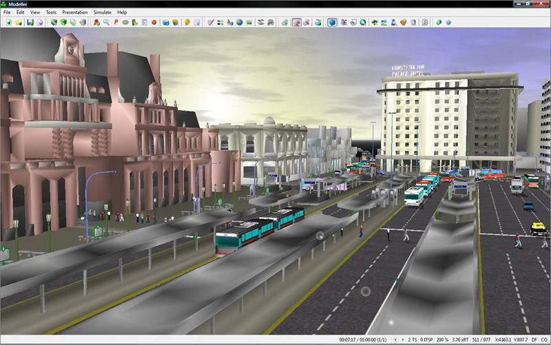
Realistic 3D street scenes allow planners to convey transportation plans, and with integrated simulation they can also convey the performance of those plans. Image courtesy of Quadstone Paramics, a Pitney Bowes company.
Planning 2.0
To truly embrace this planning 2.0 concept, critical information needs to be shared with all stakeholders. Citizen feedback on proposed projects and land-use changes needs to be aggregated and shared with the community in an open and collaborative fashion that ensures transparency and accountability. Location intelligence solutions can enable feedback garnered in social networks and online groups to be displayed on a map and shared with other stakeholders. Ultimately, this empowers citizens to be an active participant in the planning process and ensures those leading the effort are taking citizen concerns into account when making decisions about existing and new development.
And the community involvement doesn’t need to end with the planning process. Following development, local officials should be able to continue to utilize these shared maps and social networks to gather feedback and information from citizens about the performance of these projects. Are there street corners that are subject to a large amount of criminal activities? Particular regions of the city that aren’t receiving timely and adequate government services? These maps can be utilized for citizens to report issues in a way that is visual and that makes it very easy for government leaders to identify trends and relationships on a spatial dimension.
Planning doesn’t happen in a vacuum…unless it’s bad planning. For planning and development to be “smart” it needs to be driven by the people. By embracing location intelligence solutions, bidirectional feedback and relevant data from multiple parties can be better aggregated and visualized, the planning can be expedited and efficiencies can be realized that dramatically reduce that lifecycle.
Author
Ahmed Abukhater
Ahmed Abukhater, Ph.D., AICP, GISP, is an architect, environmental scientist, and urban and regional planner; email: [email protected].


.jpg?width=225)