
BTS Releases National Transportation Noise Map
The U.S. Department of Transportation’s Bureau of Transportation Statistics’ (BTS) initial National Transportation Noise Map, released today, shows that more than 97 percent of the U.S. population has the potential to be exposed to noise from aviation and Interstate highways at levels below 50 decibels or roughly comparable to the noise level of a humming refrigerator.
A much smaller segment of the U.S. resident population has the potential to be exposed to higher levels of aviation and Interstate highway noise. Less than one-tenth of a percent of the population could potentially experience noise levels of 80 decibels or more, equivalent to the noise level of a garbage disposal (See Table).
The purpose of the noise map is to facilitate the tracking of trends in transportation-related noise, by mode, and collectively for multiple transportation modes. The data allow viewing the national picture of potential exposure to aviation and highway noise. The data also allow viewing of the potential exposure at the state or county level.
The National Transportation Noise Map will be an addition to the National Transportation Atlas Database (link is external) (NTAD), a set of nationwide geographic databases of transportation facilities, networks, and associated infrastructure available from the BTS Geospatial Data Catalog (link is external). The layers will be updated on an annual basis, and future versions of the National Transportation Noise Map are envisioned to include additional transportation noise sources, such as rail and maritime.
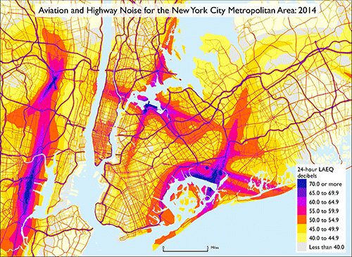
The BTS map contains aircraft and road noise inventory data provided as web map services (WMS) for use with Geographic Information Systems (GIS), computer programs that can store, analyze, and present spatial or geographic data.
The geospatial data provides a basis for understanding what-if scenarios and helping policy makers to prioritize noise-related transportation investments. Using the National Transportation Noise Map data, BTS highlighted the percentage of total U.S. resident population that had the potential to be exposed to the following A-weighted 24-hour equivalent sound levels (LAEQ) (a-weighted, average sound level for the day) from aviation and Interstate road noise in the year 2014.
Percent of U.S. Population with the Potential to be Exposed to Transportation Noise: 2014
| A-weighted 24-hour LAEQ (dBA) | Common comparable sounds | Aviation | Road (Interstate) |
|---|---|---|---|
| Less than 50 | Refrigerator humming (~40 dBA) | 97.12 | 98.00 |
| 50 to 59 | Quiet office (~50 dBA) | 2.65 | 1.30 |
| 60 to 69 | Conversational speech (~60 dBA) | 0.21 | 0.44 |
| 70 to 79 | Vacuum cleaner (~70 dBA) | 0.01 | 0.25 |
| 80 or more | Garbage disposal (~80 dBA) | < 0.01 | 0.06 |
Notes and sources for this table.
This national, multimodal transportation noise mapping initiative used data sources from the Federal Aviation Administration (FAA) and Federal Highway Administration (FHWA) to create a comprehensive map of noise levels. The FAA’s Aviation Environmental Design Tool was used to model the average number of daily flight operations from airports across the country, excluding airports with exclusively military operations. To determine daily road noise data, algorithms from the FHWA’s Traffic Noise Model were used in conjunction with data from the Highway Performance Monitoring System to obtain the average daily noise levels for automobiles, medium trucks, and heavy trucks. The acoustics modeling used in developing these noise layers uses conservative, simplified methods, and only considers transportation noise (no other ambient noise sources). Documentation on the modeling assumptions is available at https://maps.bts.dot.gov/noise/. The noise data in the layers should be used for the purpose of tracking trends, not for assessing impacts. This data release represents the first year of data that can be used to analyze future trends.
