
Creating Real-time Navigable 3D Infrastructure Models
Designing successful infrastructure projects is one thing. Communicating and demonstrating those designs to clients and other stakeholders before construction is another. Bringing a design to life for people without a civil engineering background is always a challenge, whether your goal is to sell the design or communicate its impact.
Over the decades, civil engineers have used everything from elaborate hand drawings to carefully constructed physical models for this purpose. Then, in the 1990s, as sophisticated software and high-powered computers became available, a new possibility emerged: 3D digital models. The art of digital design visualization was born.
Now things are going even further. Civil engineers on different continents are taking visualization to new levels using tools and workflows that enable them to create 3D models that can be viewed and explored in real time, just as though the viewer was walking or flying through the completed project. According to Lars Eid Nielsen, a civil engineer with Norwegian firm Multiconsult ASA, “Presenting the design in a representative 3D context helps with communication with the client, making it easier to make the right decisions from an early phase.”
“The civil engineering world has been disrupted,” says Andy Carter, co-owner of CivilE, LLC, a civil engineering firm based in Austin, Texas. “In the past, only large projects had the budget for visualization. Autodesk’s tools have empowered civil engineering firms to create compelling visualizations even under the constraints of smaller budgets.”
At Autodesk University 2015 in Las Vegas, these 2 different civil engineering teams presented their visualization processes—and the impressive results they achieved.
Models Instead of Drawings
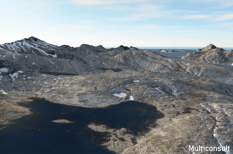
In Norway, with its abundant rainfall, 25,000 km of coastline and massive fjords that drop to the sea, it’s no wonder that 96% of the nation’s electricity is generated through hydropower. Hydropower plant design processes are well established, and new plants are rare. But when Multiconsult ASA was commissioned to design the new SmiSto Hydropower Project on Norway’s rugged northwestern coast, they decided to do it a bit differently. “Our goal has been to use the 3D model as a center for communication through the entire project, without having to create any drawings,” says Gøran André Hansen, a civil engineer who designed the project with partner Nielsen.
Together, the pair relied on Autodesk InfraWorks and Autodesk Infrastructure Design Suite software. They jumped back and forth between Autodesk AutoCAD Civil 3D, Autodesk Revit, and Autodesk Dynamo Studio software for various tasks, but “every step of the way, we bring it all into InfraWorks to create a multi-disciplinary coordinating model.”
They started by bringing all available terrain data into Civil 3D, including point cloud data from an aerial LiDAR scan and a 50 x 50 m DEM terrain model provided by the government. They also brought in government aerial photos. “It can take some time to bring these files into InfraWorks, but once you do, it’s all fast and easy to work with,” says Nielsen.
Sonar recordings from boats provided the underwater topography of the lakes and the sea, just like terrain files. Additional data was introduced as Web Map Service (WMS) files, including information about cultural heritage sites and risk areas, such as avalanche-prone slopes. Existing structures can be imported and positioned in their correct locations in the InfraWorks model. Given the rural nature of the terrain, the only existing structures the team had to worry about were power line towers, which they brought in and positioned using Revit, Civil 3D, and Dynamo for scripting. “It’s about getting all the relevant data into the same model,” says Nielsen. “By giving all team members the best possible overview of limiting factors in the project, the chances of working towards a successful design from the start improve dramatically.”
Then it was time to start designing. Eventually, the project would encompass 27 km of tunnels, 4 reservoirs, several dams and creek intakes, and 2 different underground power stations that housed the turbines. They used Civil 3D to design the tunnels, with Dynamo to write scripts for flexibility. They used Revit for the concrete structures, like the dams and the power stations, again turning to Dynamo Studio when they needed special adaptation.
At each step, the team exported files, keeping the updated design collected in InfraWorks. The end result is a digital model of the area and the project that can be freely explored (see video). “We can generate great visualizations directly from InfraWorks, we don’t even have to bring it into 3ds Max,” Hansen explains.
This fly-through of the SmiSto Hydropower 3D model was created in InfraWorks by Gøran André Hansen and Lars Eid Nielsen, of Multiconsult ASA.
As the project moves into the construction phase, the team is focusing on building without the use of drawings. The design is shared by exporting IFC and LandXML data, which can be directly used by the contractor. “If the contractor needs drawings, they can produce details themselves. All we produce are models at this point,” says Hansen.
The team is developing an additional step: putting the InfraWorks model on a GPS-enabled iPad, giving clients the ability to explore the project with augmented reality. While not yet a standard practice, the process shows promise. “Our client got pretty inspired by this, which has also inspired us,” says Hansen.
Gaming the System with CivilE
Andy Carter, co-owner of the civil engineering firm CivilE, uses another workflow to achieve similar, if possibly even more, dynamic results. He finds that his 5-person firm can compete against much larger firms in part because they can quickly and easily generate dynamic visualizations. “Knowing a client can interactively visualize our designs before a spade of dirt is turned, that’s exciting,” says Carter. “Whether that’s with a virtual reality headset, on a screen, or projected—we have found this to be the best way to engage stakeholders.” It was this visualization work that contributed to CivilE winning in the Small Project category at the 2015 Autodesk Excellence in Infrastructure Awards.
As with the Norwegian team, Infrastructure Design Suite provides most of the tools Carter needs. He uses AutoCAD Civil 3D to combine the original 2D land plan drawing with the grading plan for the site. In InfraWorks, he introduces terrain data, including government files and aerial survey data. Back in Civil 3D, he adds coverages to the various materials on the site, such as grass and asphalt. Then he applies simple 1-color textures for each, saving the detailed texture application for later in the process. Trees are placed and scaled based on field-surveyed coordinates. Then he brings it all into InfraWorks to create a grade-accurate 3D mesh file of the site design, after which it is exported as an FBX file.
The building model is created in Revit and exported as a DAE file. The FBX file and the DAE file are both then brought into Autodesk® 3ds Max® animation software, where final adjustments to materials and coordinates are made.
Now it’s ready for the final step: bringing the entire model into a game engine. “You can use whatever engine you want,” Carter points out. “Unity, Unreal, or Autodesk’s new 1, called Stingray. Currently we use Lumion, a game engine marketed specifically to architects, since it works well with InfraWorks site data.”
This fly-through of a CivilE project, Walnut Park, was created by Andy Carter.
Once in Lumion, Carter chooses textures from the library to make the grass, asphalt, stone, and other textures realistic. He can replace trees for effect. He can also add other elements, like cars and plants, to make the site seem more realistic. He also adds a filter for the light to create ambiance. “By capitalizing on real‐time engines, we can shortcut long rendering times to create accurate visualizations quickly,” he says.
The result is an immersive 3D model of the site plan that the user can explore, much like a player can explore a first-person shooter game (see video). With Autodesk Stingray, Carter even inserted a controllable animated character that he used to shoot harmlessly at the objects in the scene, but admits that’s just for blowing off steam with his team (see video).
This clip, created by Andy Carter of CivilE, shows a first-person shooter character firing harmless rounds at an actual 3D model designed by the firm.
Turning Designs into Worlds
While these civil engineering teams used different workflows, they arrived at similar results: fully realized 3D worlds that can be explored in real time by anyone, whether they know anything about civil engineering or not. As Carter says, “It’s a quick and easy way to create concept renderings and communicate the site plan with investors, bankers, and the public.”
While these tools and workflows are relatively new, Carter believes they hold enormous potential for the industry in the near future. “If you can build 3D content in real time, you’ll be king in 2 to 3 years,” he says. Whether you adopt 1 of the workflows described or invent your own, it’s clear that creating this kind of design visualization will become an increasingly important way to win business and communicate with partners. “Soon your clients will expect 3D preconstruction visualizations of every project you design,” Carter says. Luckily, as the tools evolve, creating those visualizations gets easier every year.
You can watch both presentations, as well as download handouts and associated materials, at Autodesk University online anytime.
Watch “Case Study: The Use of InfraWorks and the IDS for a Hydropower Project in Norway” with Lars Eid Nielsen and Gøran André Hansen. Together, they won the “Rookie of the Year” speaker award for AU 2015.
Watch “Gaming the System: Combine AutoCAD Civil 3D, Revit, InfraWorks, and Game Engines for Sites” with Andy Carter.
