
Wetlands Worth their Weight
Monitoring, Managing and Protecting Ecological Powerhouses
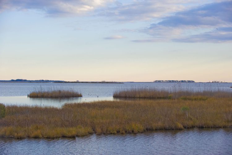
“Wetland” is a generic term covering a wide variety of habitats that are wet for at least some period of time each year, have vegetation, and have soils that are saturated long enough during the growing season to produce oxygen-deficient conditions. Although they can vary tremendously depending on climate and topography, all wetlands promote the growth of different types of microbial, plant and animal communities.
Wetlands attenuate floods, help steady the water supply, and improve it by filtering out nitrogen and other nutrients. They’re also an important habitat for many fish, wildlife and plant species—and the venue for many recreational activities such as fishing. For these reasons and more, protecting wetlands is a key environmental concern.
In the United States, federal agencies such as the U.S. Geological Survey (USGS) and the Environmental Protection Agency (EPA), state environmental and land-management agencies, and private conservation organizations such as The Nature Conservancy (TNC) play significant roles in monitoring, managing and protecting wetlands. USGS’ principal role is to provide scientific data and advice to other federal agencies. EPA, a regulatory agency, generally doesn’t restore wetlands directly, but it provides grant funds to agencies and organizations that do so, and TNC has purchased and restored wetlands across the country.
Historically, wetlands protection has been one of the greatest achievements of the conservation movement. However, these achievements are challenged by changes in land use and climate.
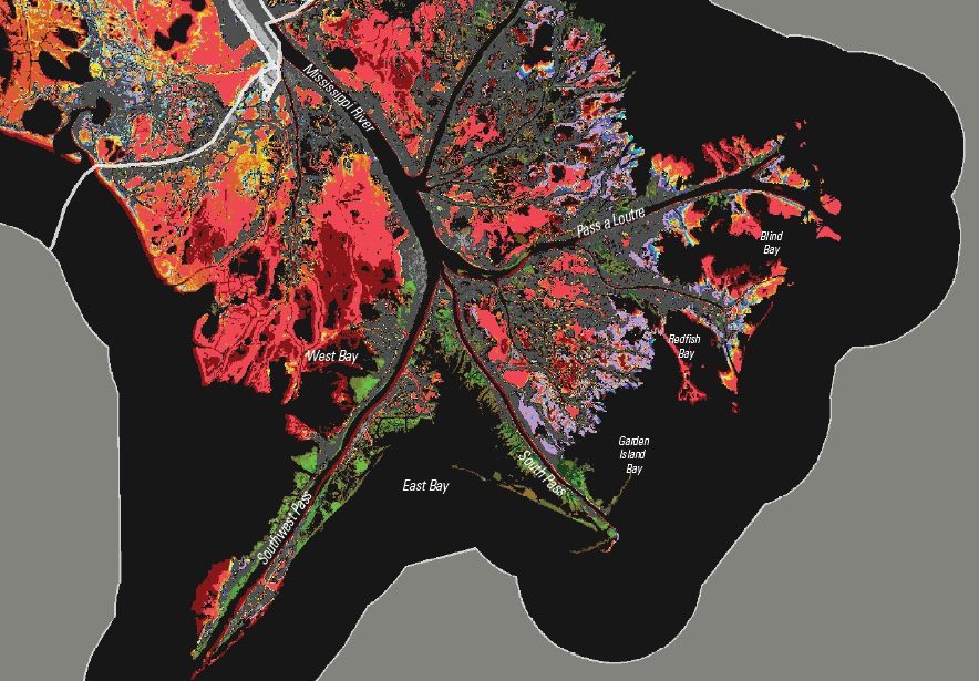
The extreme land loss experienced in the Mississippi River’s Birdsfoot Delta is seen in this image. Reds, oranges, yellows, and purples indicate land that has converted to water. Greens and browns indicate areas of land that have been gained.
Threats to Wetlands
“The various threats to wetlands are generally ubiquitous and include conversion of wetlands to other land uses, climate change, freshwater inflow and saltwater intrusion,” says Mike McDavit, branch chief, Wetlands Strategies and State Programs Branch, Office of Water, EPA.
Among the biggest stresses to wetlands are changes in their hydrology, such as by building dams and withdrawing a lot of water to irrigate crops, notes Dr. Allison Aldous, director of Research and Monitoring at The Nature Conservancy in Portland, Ore. She specializes in freshwater, ranging from groundwater protection to stream and wetlands restoration to freshwater conservation policy.
Climate change has a huge effect, particularly on water availability. According to climate-change predictions, winters will have smaller snow packs and more rain.
“Our snow pack is essentially our summer water in the West,” notes Aldous. “So if we are not storing our water as snow, but, instead, it is falling as rain and running off the landscape, then, come August, we don’t have a lot of water left in the rivers and thus in the wetlands and aquifers.”
Climate change also affects other processes within wetlands. “Climate warming can do things such as speed up microbial metabolism and cause profound but unseen alterations in the soil profile and in the way plants grow,” adds Aldous. “The lack of summertime water can draw the water level down in wetlands to a point beyond which they start to metabolize the carbon they’ve stored over many years—in some cases thousands of years.”
Another major issue that’s difficult to address is threats to water quality, especially runoff from nonpoint sources—from agriculture to leaky septic systems to livestock grazing in the riparian zone or floodplain. Conversion of wetlands to other uses (e.g., agriculture and urban, suburban or industrial uses) has a major effect on water quality and habitat availability.
In Oregon’s highly cultivated Willamette Valley, a lot of development has occurred in former floodplain habitats.
“Floodplain wetlands tend to accumulate a lot of gravel, so we have many gravel mines, particularly old, historical ones—deep pits that have been dug out in the floodplain,” adds Aldous. “This is a worldwide issue. A lot of agriculture takes place in floodplains.”
In addition to losing the habitat, this often requires building levies to separate the river water from the agricultural piece, thereby disconnecting that habitat from the river system. “Connected habitats are really important,” notes Aldous. “Many fish species have their nurseries in that kind of floodplain habitat. Where it is more protected, it is usually a little bit warmer, they can grow faster.”
A recent scientific assessment of wetland condition undertaken by EPA and the states describes the ecological condition of wetlands at national and ecoregion scales as well as stressors most commonly associated with poor condition. EPA recently released a draft report documenting the study’s findings (visit www.epa.gov/national-aquatic-resource-surveys/national-wetland-condition-assessment-2011-results). Nationally, vegetation removal, surface hardening (e.g., pavement and soil compaction), ditching and the presence of nonnative plants were found to be the most widespread indicators of stress (visit www.fws.gov/wetlands/Status-and-Trends/index.html).
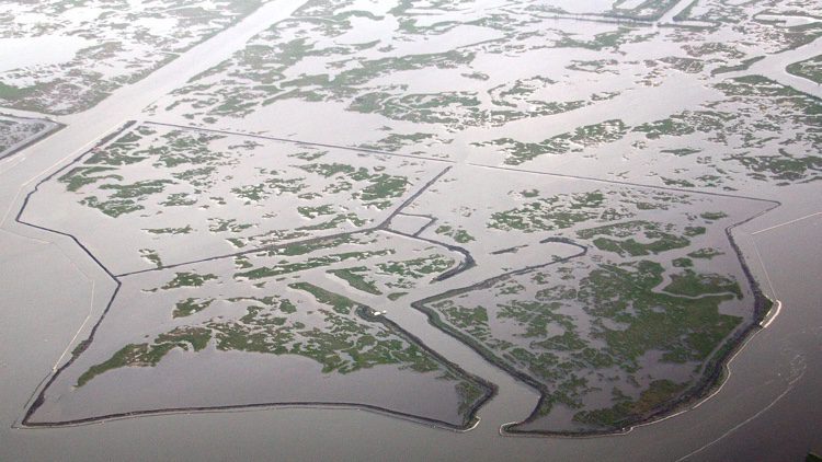
This overview of the Barataria Basin Landbridge Dredging project shows the deteriorated condition of the marshes in the project area.
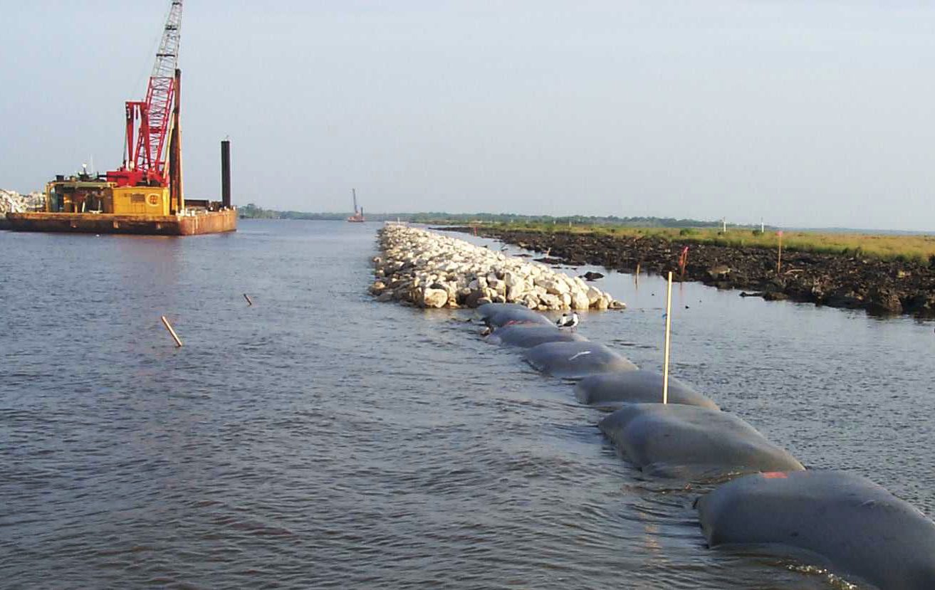
Geotextile fabric bags were filled with lightweight aggregate, supporting the shoreline stabilization structure.
Monitoring Wetlands with Ground- and Space-Based Sensors
An essential component of wetlands protection and restoration is monitoring, because “you can’t manage what you can’t measure.” To this end, scientists collect data in real time with in situ sensors placed on the ground. They also analyze land-use changes from satellite imagery and aerial photography. The most-extensive wetlands-monitoring program in the United States is in coastal Louisiana, where annual wetlands loss is the greatest.
“The estimate is that we lost 16.5 square miles per year from 1985 to 2010, due to a variety of factors, some of which are anthropogenic and some of which are not, largely because the Mississippi River has been levied and is separated from its associated wetlands in most parts of the state,” says Sarai Piazza, a USGS ecologist.
She has been working for about 10 years for the USGS Wetland and Aquatic Research Center, mainly monitoring vegetated wetlands within the coastal zone of Louisiana. “We monitor to address land-loss issues, largely, and to get a basic understanding of how coastal wetlands function in Louisiana.”
Piazza’s wetlands-monitoring work is part of the Coastwide Reference Monitoring System (CRMS), a network of about 390 sites within different types of coastal wetlands in Louisiana. “We monitor vegetation, hydrology, soils and land change,” explains Piazza. “We have on-the-ground monitoring stations that collect ecological data, and then we also use some satellite-imagery-based land-change analysis. We also do land-change analysis through high-resolution aerial photography.”
At all its sites, CRMS uses continuous hydrologic data recorders that monitor salinity, water level, pH and temperature every hour.
“To monitor surface-elevation change and accretion, we use a surface-elevation table, so we can get millimeter-accuracy estimates of how the surface elevation of the wetlands changes through time, and how sediment is brought in, influencing accretion processes through time,” explains Piazza. “Then we monitor vegetation annually on the ground in our coastal marsh sites, which are the majority of our sites. We have swamp sites as well, where we monitor not only the herbaceous vegetation on the ground, but also the trees and the canopy cover at those sites.”
Because coastal land loss is a major issue in Louisiana, CRMS monitors the health of coastal wetlands as well as their disappearance.
“Our network enables us to look at all types of good-quality and, maybe, poor-quality wetlands within and outside restoration project areas,” adds Piazza. “We are able to tease out those sites within restoration projects that are implemented on the ground, and look at trajectories of change in terms of how the hydrology, vegetation and soils are doing compared to the entire network.”
Louisiana has fresh, intermediate, brackish and saline marshes, which are largely defined by their species composition and hydrology (i.e., salinity and flooding regimes). The land-change analysis reveals whether wetlands are disappearing as well as which types of wetlands are being converted from one to another.
“Many of our restoration projects focus on restoring hydrology to a particular wetland that maybe has been impounded,” says Piazza. These restoration efforts include building water-control structures to return fresher water into impounded areas and creating marshes, sometimes using dredged material.
“We often plant those marsh-creation projects with vegetation and then let the natural wetland processes take over,” adds Piazza. “That wetland can develop through time, where it might have converted into open water.”
If not properly designed, Aldous cautions, monitoring programs can be “a big black hole” that costs a lot of money but doesn’t achieve any useful goal.
“When we develop monitoring plans, we are very specific about what our objectives are,” she notes. “There is no one-size-fits-all monitoring. If your objectives are to restore flow, so that you build habitat for a certain species of frog, then your monitoring plan may involve monitoring the water flow and frog population. There is no point in monitoring that frog in another habitat if your objective has nothing to do with that frog.”
Regional Restoration
Louisiana’s challenge with wetlands has prompted a regional response. The CRMS network is funded by the Coastal Wetlands Planning, Protection and Restoration Act (CWPPRA), a national program that implements coastal wetlands-restoration projects. In Louisiana, the CWPPRA group includes six federal agencies—EPA, USGS, the Department of Agriculture, the Army Corps of Engineers, the Fish & Wildlife Service, and the National Marine Fisheries Service—all working together to implement restoration on the ground, with USGS as the federal sponsor for the wetlands-monitoring portion. The program is a state/federal partnership in which federal agencies and the state of Louisiana share the cost.
In some places, local agencies take the lead. The Gulf of Mexico Program (visit www.epa.gov/gulfofmexico/why-habitat-restoration-near-gulf-mexico-essential) and the Brownsville Public Utilities Board (the main municipally owned utility company in the city of Brownsville, Texas) have chosen a “resaca,” a geographical feature in the Rio Grande basin, as the first in the area for wetland-habitat restoration.
“Years of agricultural influences, urban development of roads and houses, and use of bulkheads to control beach erosion have resulted in decreased water depth, water quality and water circulation,” explains McDavit. “Over the next year, the focus of this project is to restore aquatic and riparian habitat, which are located on the bank of a natural watercourse.”
The Breuner Marsh Restoration Project (visit www.epa.gov/sfbay-delta/breuner-marsh-restoration-project) will create, restore and enhance 164 acres of wetlands and uplands habitat along the Point Pinole Regional Shoreline in Richmond, Va. The restored area will be a self-sustaining tidal wetlands area with adjacent seasonal wetlands and coastal prairie habitats, and it will provide a key link in the Bay Trail system. The project is designed to accommodate a sea-level rise of 55 inches by 2100 and includes uplands allowing the wetlands to transgress inland. Site preparation has already begun, and the project is estimated to be completed in 2016.
Climate change has made the role of wetlands more important than ever, because they can help mitigate sea-level rise. In the wake of Hurricane Sandy, for example, wetlands were discussed as possible alternatives to storm-surge barriers to protect New York City’s shoreline, because their rough surfaces dissipate wave energy and capture debris that would otherwise end up on streets or battering buildings.
However, wetlands restoration and construction projects face many environmental, economic and regulatory constraints in a heavily developed urban environment. It’s time for federal, state and local government agencies, in concert with nonprofit environmental organizations and the private sector, to face these challenges head on, and give wetlands conservation and restoration efforts the high priority they deserve.
Using Anammox Bacteria to Treat Wastewater
One aspect of restoring wetlands is removing pollution such as nitrogen. Anammox bacteria can help.
By Dr. Peter Grevatt, director, Office of Ground Water and Drinking Water, and Christopher Impelliteri, associate director, Safe and Sustainable Water Resources Research Program, U.S. EPA.
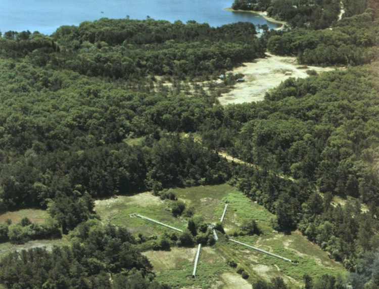
This aerial image of the Joint Base Cape Cod shows the wastewater infiltration beds in the middle that are monitored for anammox , the nitrogen-contaminated disposal beds in the middle, and a freshwater pond in the background.
Nitrogen (in the form of nitrate or nitrite) in groundwater used for drinking can have harmful health effects. In addition, nitrogen-contaminated groundwater can contribute nitrogen pollution to surface waters, which can lead to algae blooms that deplete oxygen in water and harm fish. Sometimes these blooms contain toxic algal species that can make surface waters unsafe for swimming or put drinking-water supplies at risk.
Agriculture is a large user of nitrogen fertilizer and a major source of nitrogen in ground and surface waters. Other sources of nitrogen in groundwater include lawn fertilizer, onsite wastewater-treatment systems, leaky sewer lines, municipal treatment lagoons, application of manure in excess of crop needs, and manure storage in unlined lagoons. Preventing nitrogen pollution of groundwater avoids illnesses and treatment costs for drinking water, while avoiding impacts to recreational activities such as fishing and swimming.
Anaerobic ammonium oxidation (anammox) bacteria (AB) were discovered in wastewater sludge in the 1990s. They form nitrogen gas by metabolizing ammonium and nitrite or nitrate. Naturally occurring AB have been discovered in marine and freshwater environments, including sediments and anaerobic water columns. They’re very sensitive to oxygen, and their growth can be inhibited by very low oxygen levels. In addition, ABs are slow growing compared with many other bacterial species.
Scientists can increase AB populations by optimizing their growth conditions, which is being done for industrial treatment processes. Efforts to increase naturally occurring ABs in natural environments likely aren’t practical, because ABs already are ubiquitous in anaerobic water environments.
From an industrial perspective, the anammox process can be extremely helpful in treating wastewaters high in ammonia. Sources of such wastewaters include municipalities (from sewers and toilets), food-processing plants, animal manure and fertilizer manufacturing. For municipal wastewater treatment (and other types of treatment such as industrial wastewaters high in ammonia), the process of nitrification often is used to remove ammonia. Nitrification depends on bacteria, which can be finicky and sensitive to changes in environment.
These bacteria also need a steady supply of oxygen. Wastewater treatment plant operators typically supply such oxygen through air bubbles pumped into the wastewater. The aeration process consumes a significant amount of energy and is costly for the plant.
The anammox process has the potential to eliminate the need for aeration to remove ammonia, thereby cutting costs. The process of nitrification also only converts ammonia to nitrate, which requires another treatment step for removal. Anammox converts ammonia to nitrogen gas, which saves the plant additional treatment steps.
Currently, the anammox process can be used for large-scale industrial processes. Engineering a large area to remediate a site for high ammonia concentrations likely wouldn’t be practical, but ABs will thrive under adequate conditions, and it may be possible to cost-effectively maintain and optimize these conditions depending on the nature of the site.
Experts in the field are working to identify the relationships among ABs and other organisms such as denitrifiers (bacteria that convert nitrate to nitrogen gas in environments without oxygen) and how these bacterial communities work together (or not). Researchers also are studying ways to accelerate AB growth and methods to optimize conditions for maintaining robust AB populations for treating wastewater.
About Matteo Luccio
Matteo Luccio has nearly twenty years of experience as a magazine writer and editor. He has a master’s degree in political science from MIT and co−founded the public policy magazine Oregon’s Future, which he edited for four years. For the past twelve years he has edited and written articles for technical magazines on geospatial technologies, the last five as president and founder of Pale Blue Dot.
